WATCH: Two months worth of rain fell in a matter of hours Monday night, trapping people in cars and flooding homes in Burlington, Ontario. Eric Sorensen reports on the damage.

TORONTO – On Tuesday, for the fifth day in a row, Environment Canada issued a thunderstorm watch for parts of Ontario.
This follows the incredible deluge the city of Burlington endured over the August long weekend.
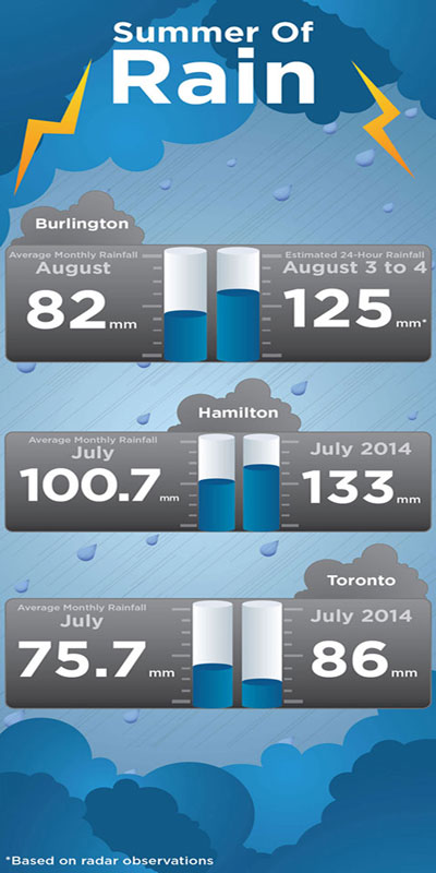
From about 2 p.m. on Monday to roughly 9 p.m., the city of Burlington received about 125 mm of rain (estimates were achieved using radar), but there is the chance that localized heavier amounts fell in some areas.
While it wasn’t necessarily record-setting, the effects were extreme: several basements of homes were flooded.
“We don’t actually have an Environment Canada measurement site that reported a number, so I can’t say it was a record because I can’t compare with anything,” Peter Kimball of Environment Canada said.
Kimball said that it wasn’t even a record for Ontario. Looking back to 2013, on July 8, Toronto broke its record when it received 126 mm of rain causing widespread flooding.
“Every summer somewhere in Ontario this thing happens somewhere,” he said. That being said, he added, “It was a heavy rainfall, it was more than a month’s worth of rain that fell in a six-hour period.”

Get breaking National news
Why the rain?
Southern Ontario has had somewhat of a strange summer: as of Aug. 5, there have been no heatwaves. Toronto hasn’t even reached one day where the temperature climbed above 30 C.
Though we’ve had a fair amount of sunshine in the past few months, when it rains, it rains.
In Toronto, the amount of rain was 97 mm for the month of June, above the monthly average of 71.5 mm. But most of that rain fell over three days where the city received more than 20 mm of rain in one dumping. In July, the city received 86 mm, above the norm of 71.5 mm, with more than half falling over three different days.
The rain is due to different frontal systems pushing through the region. If the atmosphere is moist and unstable enough, it will create thunderstorms, some severe, as we’ve seen over the past month.
But Monday’s rain was more an effect of the lake breezes. The moist air lingered and the cooler breezes off the lake made for the perfect rainy conditions. With no air aloft (higher in the atmosphere), the moist air below remained in place.
“And therefore you have potential for redevelopment of thunderstorm cells over the same area again and again and again,” Kimball said.
Though the rain in southern Ontario has been substantial over the past few weeks, nowhere in Ontario has seen more rain than the northwestern part of the province.
“If anything it’s been a rainy summer, but particulary for places in northwestern Ontario,” Kimball said. “They’ve had a ton of rain…over the spring and summer.”
Watch: How much rain has the GTA received this summer? Michelle Jobin reports.
In Fort Frances, for example, the city received 231 mm of rain, far above its normal average of 113 mm. Kapuskasing received 175 mm over the month of July, above its norm of 101.9 mm.
The good news for southern Ontario is that a ridge of higher pressure will be pushing through on Wednesday, breaking the pattern, leaving days of mostly sunshine ahead.


Comments