CALGARY – A long and snowy winter in Alberta isn’t necessarily a precursor to another year of flooding like the province suffered through in 2013, says a government official.

Alberta Environment and Sustainable Resources checks the snowpack each month and says the snowpack was only slightly above normal compared to last year in the last measurement March 1.
Spokeswoman Carrie Sancartier says the overall snowpack is 110 per cent of normal. There are four areas that have received a record amount of snow but those are in the North Saskatchewan basin so she said they wouldn’t have an impact on southern Alberta. The snowpack in the Bow River basin in southern Alberta is 103 per cent of average.
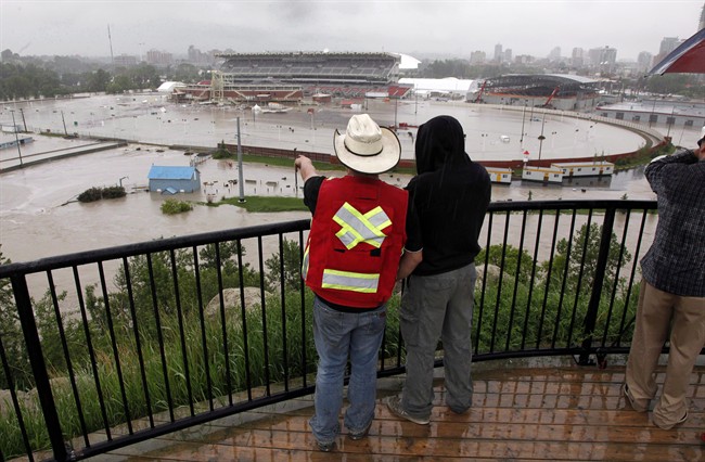
Severe flooding in Calgary and High River last June was more of a result of heavy rainfall than the snowpack, Sancartier said. One station west of High River recorded 325 millimetres in under 48 hours.
“One of the things our forecasters really try to focus on is things like what happened last year. The massive river-related floods tend to be driven by rainfall and so we’re a couple of months away from getting rain,” said Sancartier.

Get breaking National news
“The rainy period is usually mid-May to mid-July so we’ve still got some time. If we continue to do the nice weather during the day so it melts and then cool at night so it freezes again. that’s a great scenario in terms of snowmelt.”
Sancartier said there was a near record snowpack in southern Alberta in 2012 but flooding was not a problem.
- Global Calgary chief meteorologist Tiffany Lizée joins evening newscasts in Calgary and Lethbridge
- Family has car stolen from Calgary airport
- Court orders WestJet to give files on alleged flight attendant harassment
- Number of Albertans receiving income support reaches highest total since 2019: government data
“The rain that fell that year was not nearly to the scale we saw in June 2013. Although the snowpack was very high, there were no widespread flood events,” she said.
But snow is part of a potential recipe for disaster, says Bob Sandford, chairman of the Canadian Partnership Initiative of the UN Water for Life Decade.
Sandford said the heaviest snowfall comes in March and April. If the snow melts slow and steady, he said everything should be all right. But he added if rain comes down on top of the snowpack, then there’s a reason for concern.
“The thing you’ve got to fear and truly and genuinely fear is a big, warm rain event on snow. That’s one of the things that caused us a lot of problems last June,” said Sandford.
He said warm rain on snow and frozen soil will not sink into the ground and will result in massive streams forming. Sanford said the second problem is the melting snow can cause vapour, which can re-form as rain in a storm event.
“Man, oh man — rain on snow events are to be feared. We don’t know yet what will happen,” said Sandford.
“We may have a gradual, cool spring that could help us a great deal. We could also conceivably get a lot of snow yet before the end of April and we’ll have to see.”
Follow @BillGraveland on Twitter


Comments