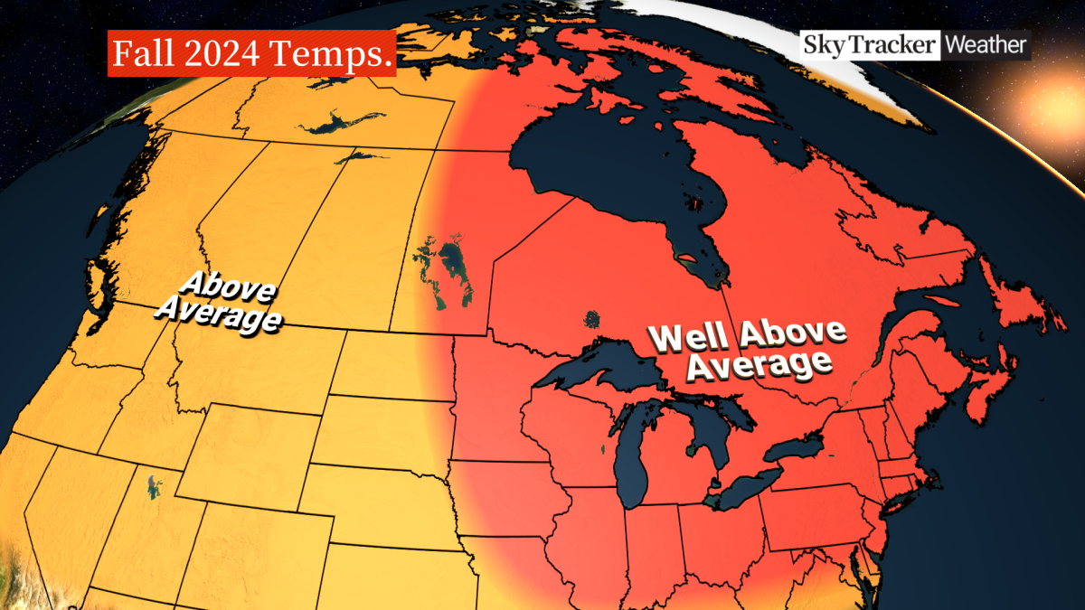
After a warmer-than-normal summer, Canadians can expect the warm weather conditions to stretch into the fall, meteorologists say – and that means leaf peepers will have to wait a little while longer.

“A trend of above-normal temperatures” is forecasted for the rest of September and October across the country, according to Global News meteorologist Ross Hull.
“It’s going to be a warmer-than-normal (fall) for much of the country, especially eastern sections of the country,” Hull said.
Dominant air masses and air flows coming up from the United States seem to be influencing these warmer-than-normal conditions, said Geoff Coulson, a warning preparedness meteorologist with Environment Canada.
“Many of these air masses, especially in more southern parts of the country, are influenced by air masses coming up from the U.S. and that certainly looks to be the dominant flow,” he said in an interview with Global News.
But the warmer conditions are not going to continue throughout fall, Coulson and Hull said, as stretches of cooler weather are also expected.
“It doesn’t mean that we won’t see these cold air intrusions once in a while that delivers in cooler air for a period of days, and then that warmer weather takes over after that,” Hull said.
Here is what fall is looking like for different parts of the country.
Central and Eastern Canada
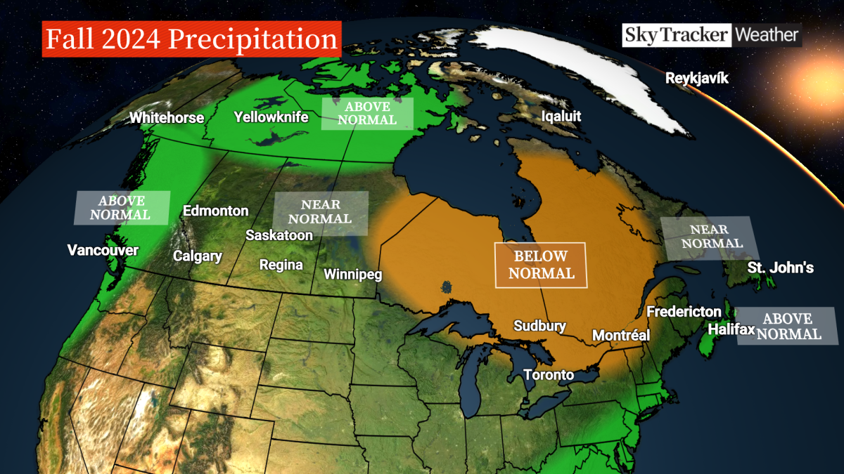
Central and eastern provinces have so far experienced “the driest stretch of weather” all year this September as well as above-average temperatures and those weather patterns are expected to continue for much of the region, Hull said.
Much of Eastern Canada won’t be getting any typical fall storms and they won’t be as frequent, he said.

Get daily National news
However, after a lull in the Atlantic hurricane season, activity is “starting to increase.”
“The one thing that we’re looking at, especially for the Maritimes in Atlantic Canada, parts of southwestern Quebec, even southern Ontario, is the Atlantic hurricane season,” Hull said.
It remains to be seen if any remnants of tropical storms make their way to the Atlantic Canada and “that could obviously bring us some heavier rain at times this fall season.”
Western Canada
For the Prairie provinces – Alberta, Saskatchewan and Manitoba, there will be a continuation of “warmer-than-normal” conditions to finish off September and going into October, Coulson said.
Likely normal amounts of precipitation are forecast over the Prairies, according to Hull.
As for British Columbia, above-average temperatures are expected on the coast, South Coast and Lower Mainland, “although there will be some periods of cooler and warmer weather,” he said.
Overall, “much of the West, as well, will stay above average when it comes to temperatures.”

Northern Canada
To finish off the month of September, more seasonal conditions are expected for parts of Yukon, Coulson said.
And going into October, the northern regions, like the rest of the country, are forecast to experience above-normal temperatures.
What role could La Niña play this fall and winter?
- Old Man Winter wallops B.C.’s Mainland/Southwest region, major highway closed
- Calgary hit by unexpected blast of spring snow, causing dozens of crashes
- False spring strikes again: Saskatchewan prepares for incoming winter weather
- Albertans’ interest in alternative forms of travel growing as fuel prices spike
Currently, the Pacific Ocean currents are in a neutral pattern, meaning there is neither El Niño nor La Niña.
But the forecast shows that La Niña could develop in the coming months – and that could play a role in the weather conditions this fall and winter.
“We are expecting La Niña to build as we move through the fall and winter months,” Hull said.
“It’s not expected to be a strong La Niña, more of a weak La Niña, which can provide some forecast challenges just because it’s a weaker signal.”

During La Niña years, trade winds are stronger and water temperatures become cooler than average in the eastern Pacific Ocean near the equator. Hence, the northern U.S. and Canada tend to be wetter and colder.
Hull said during a typical La Niña fall and winter, there are higher amounts of rain and snow on the West Coast. It can also lead to more storms than normal, with an active hurricane season.
In the Prairies, La Niña often delivers a somewhat colder than normal winter, Coulson added.
But not all La Niñas behave in the same way.
“We’ll have to see if this La Niña strengthens and becomes a more dominant influence as we get to the end of the fall and into the winter,” Coulson said.
When will the leaves change colour?
Fall foliage is influenced by temperature and precipitation.
The “perfect weather” to display the fall leaves is warm, sunny days and cooler nights, Hull said.
The current dry and sunny stretch will likely delay the changeover of the fall leaf colours, he said.
But the forecast is still looking favourable since there won’t be a steady stream of fall storms that can blow the leaves off the trees.
“Right now, it’s looking pretty favourable for a good display of the fall colours,” Hull added.


Comments
Want to discuss? Please read our Commenting Policy first.