


Remnants of Hurricane Beryl are set to hit parts of Canada this week, bringing the threat of localized flooding for some.

Beryl made landfall on the Texas coast early Monday as a Category 1 hurricane with a dangerous storm surge and strong winds.
“After making landfall on the Gulf coast early Monday a.m., the remnants of the storm will start to interact with a trough of low pressure moving across the U.S. and ride the upper level wind flow towards the Great Lakes,” Global News meteorologist Ross Hull said.
“By the time the remnants of Beryl reach the Great Lakes on Wednesday, it will have transitioned to a more typical low pressure system; however, the difference will be the tropical moisture it will transport across the border into Canada.”
Hull said there’s a concern for heavy rain stretching from southern Ontario, through southwestern Quebec and then into parts of the Maritimes — likely New Brunswick.
It’s still unclear which specific areas will see the heaviest rainfall, Hull noted.
“But there is the potential for anywhere between 25 mm to locally 50+ mm, which could lead to some localized flooding, especially in urban areas,” he said.
“There will be enough instability for the formation of thunderstorms too, which could also result in heavy downpours.”
In terms of timing, rain is expected to move into southern Ontario and the Greater Toronto and Hamilton Area Wednesday morning, into the afternoon.
Southwestern Quebec and Montreal will see the impacts beginning Wednesday afternoon into Thursday morning, Hull said.

Get breaking National news
And by Thursday morning, heavy rain will be moving into New Brunswick and Nova Scotia.
Areas in western Newfoundland may also see heavy rain by the end of the week, Hull said.
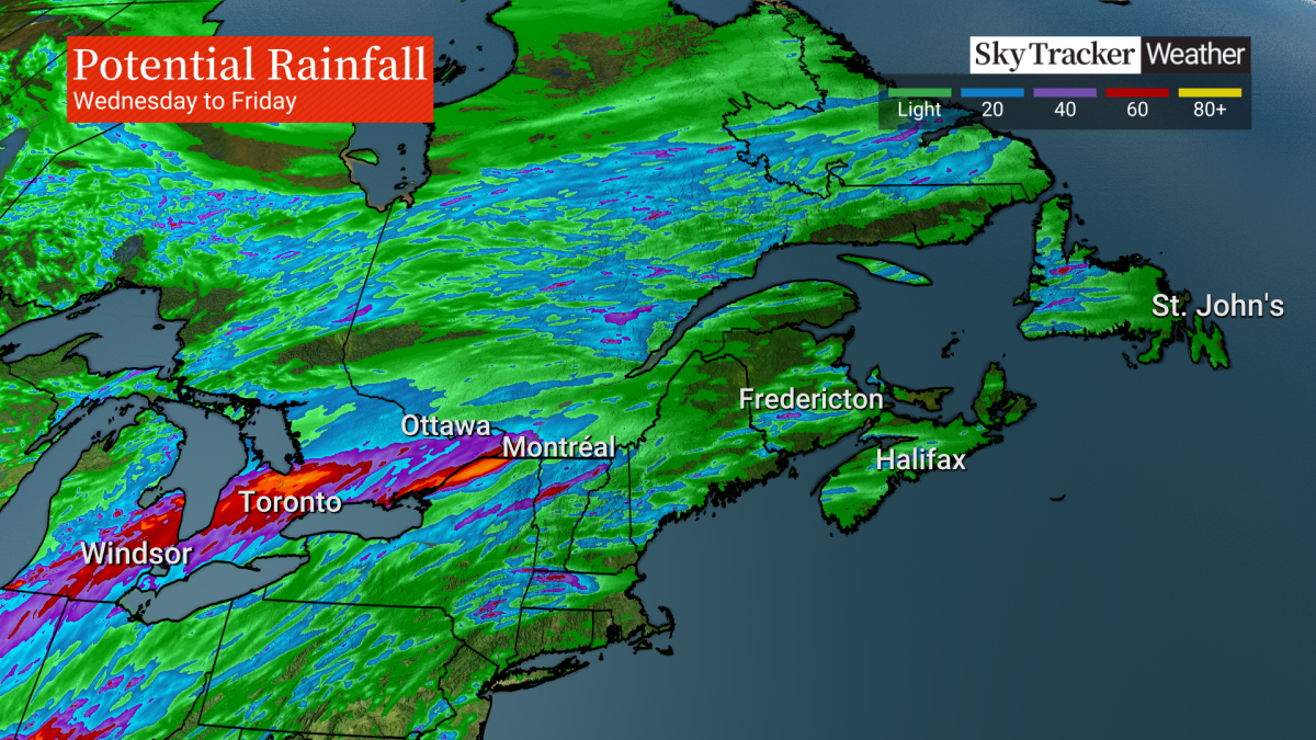
“The heavy rain should move out of southern Ontario by Thursday and southwestern Quebec and the Maritimes by Friday,” Hull said.
Special weather statements issued for most of southern Ontario, parts of Quebec
Most of southern Ontario is now under a special weather statement ahead of the system’s arrival.
“Although confidence in the exact track of the weather system is low, these types of systems in the past have given very high rainfall rates in torrential downpours,” Environment Canada said.
“Rainfall warnings may be issued as confidence in the track of the system increases.”
The weather agency said heavy rain may affect parts of southern Ontario beginning Tuesday night or Wednesday, possibly persisting into Thursday. Hazards include torrential downpours with rain amounts of 20 to 40 mm per hour at times, and local rain totals “possibly well in excess of 50 mm,” the statement said.
But confidence in the exact track of the system and rainfall amounts is currently low, the weather agency said.
Parts of southern Quebec are also under a special weather statement, including Montreal.
For the Montreal area, Environment Canada said significant rain is expected beginning late in the day on Wednesday, continuing into Thursday.
“Rainfall amounts between 40 and 80 millimetres are expected as well as moderate wind,” the weather agency said.
“Heavy rain may cause flash flooding and ponding on roads.”
Environment Canada said in its Montreal statement that there may be “significant impacts” on the afternoon commute and encouraged people to change or delay non-essential travel.
Beryl strengthened and became a hurricane again late Sunday. The storm had weakened after leaving a path of deadly destruction through parts of Mexico and the Caribbean.
The earliest storm to develop into a Category 5 hurricane in the Atlantic, Beryl caused at least 11 deaths as it passed through the Caribbean on its way to Texas.
It has since weakened again to a tropical storm and is expected to become a tropical depression Tuesday, the U.S. National Weather Service said.
— With files from The Associated Press


Comments
Want to discuss? Please read our Commenting Policy first.