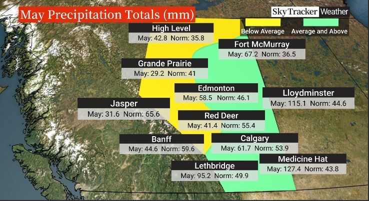
Normal to well-above normal precipitation levels in May came at the perfect time for Alberta, said Environment and Climate Change meteorologist Alysa Pederson.

“Looking back at the month of May, it’s kind of a good news story in a lot of aspects,” she said, “because most places were normal for precipitation or above normal or well-above normal.
“If you think about how dry it was November, December, January, February, going from our super, super dry winter into spring, everybody wanted to see a lot of precipitation — or at least normal to above-normal precipitation — just because the soils were already super dry. So getting this precipitation at this time of year is excellent,” Pederson said.

The benefits extend from farmers and agriculture to reducing wildfire risk, she added.
“When we look at the highest risk for wildfire starts, that’s kind of your end of April, early May, because the trees and foliage are kind of trying to suck the moisture out of the ground, and when you come off a dry winter without that moisture, everything just dries out extra quickly. It’s what we call the spring dip,” Pederson said, adding it happens every year. “That’s kind of why we want to see spring precipitation like we have this year.”
Some areas, like southeastern Alberta that have been struggling with drought, got a ton of precipitation in May, she said.
Lloydminster’s May precipitation total was 115 millimetres, compared to its normal monthly amount of 45 mm.
“Medicine Hat, for example, has had just about 300 per cent of what their normal precipitation is. And it ended up being the third-wettest May on record down there.”
A spokesperson for Agriculture Canada said large portions of Alberta received well-above normal precipitation in May, “significantly improving the overall drought situation.”
However, some regions, including the extreme southwest and northwest, have not received significant precipitation “and the drought in these areas continues to raise concerns.”

Get breaking National news
While May and June are usually the two wettest months of the year, some parts of Alberta have already seen more than double what they’d normally get.
“We are seeing significant improvement to drought conditions, especially short-term conditions,” said Agriculture Canada Alberta spokesperson Kandice Kew. “We are no longer seeing large portions of the province with precipitation deficits in the past year, however longer-term deficits still remain.”
That means some pasture productivity delays and some remaining surface water supply concerns, she explained.

Edmonton saw a total 58 mm of rain in May, compared to its normal monthly amount of 46 mm.
Fort McMurray had its 10th wettest May on record, Pederson said.
And there’s still time for more moisture. June is typically Alberta’s wettest month of the year.

“When we have high temperatures and super dry conditions, that kind of led to that fire season start that we had last year. So there was a lot of concern as we went into this year, but the forecast through the spring was for above-normal precipitation in the province and that is exactly what we saw,” Pederson said.
“There was a lot of apprehension ahead of this year’s month of May. We talk about the spring but really the month of May is when we see things like wildfire pick up.
“If you think about what happened last year, we were hitting 30 degrees for daytime high temperatures at the start of May. And that’s kind of when there’s a higher risk because the trees aren’t green yet and it’s actually quite dry.”

To anyone bemoaning Alberta’s wet start to spring, Pederson offers this:
“I keep reminding people about what can happen if we don’t get our spring rains, and that’s exactly what we saw last year. Nobody can really enjoy being outside in the summer if there’s smoke everywhere.
“Getting rain now is actually much better for what we’re going to see the rest of the summer when it comes to forest fire risk,” she said.
“It’s a bit of a Catch-22 a little bit but yeah, the rainfall in the spring is always a welcome thing.”


Comments
Want to discuss? Please read our Commenting Policy first.