
A search-and-rescue group in Vancouver says it has finally been successful in getting Google Maps to remove a non-existent hiking trail on the north side of Mount Fromme that may have stranded numerous hikers and even led to one death.

North Shore Rescue wrote on Facebook that the phony trail, which supposedly led from Mount Fromme to nearby Kennedy Falls, was removed from Google Maps on Nov. 6, two days after a lost hiker had to be airlifted out of the area.
“To be clear, the area in question has no trails and is very steep with many cliff bands throughout,” the volunteer organization wrote in an earlier post. “The area is clearly dangerous, as it was the sight of a previous fatality.”

Two years ago, a hiker fell to his death on the cliffs north of Mount Fromme, the group says. Global News reported in 2021 that a man who became separated from his hiking partner between Mount Fromme and Kennedy Falls was found dead on steep terrain.
The most recent rescue took place on Nov. 4 when North Shore Rescue learned of a hiker who was stranded after similarly attempting to climb Fromme from the Kennedy Falls area.

Get daily National news
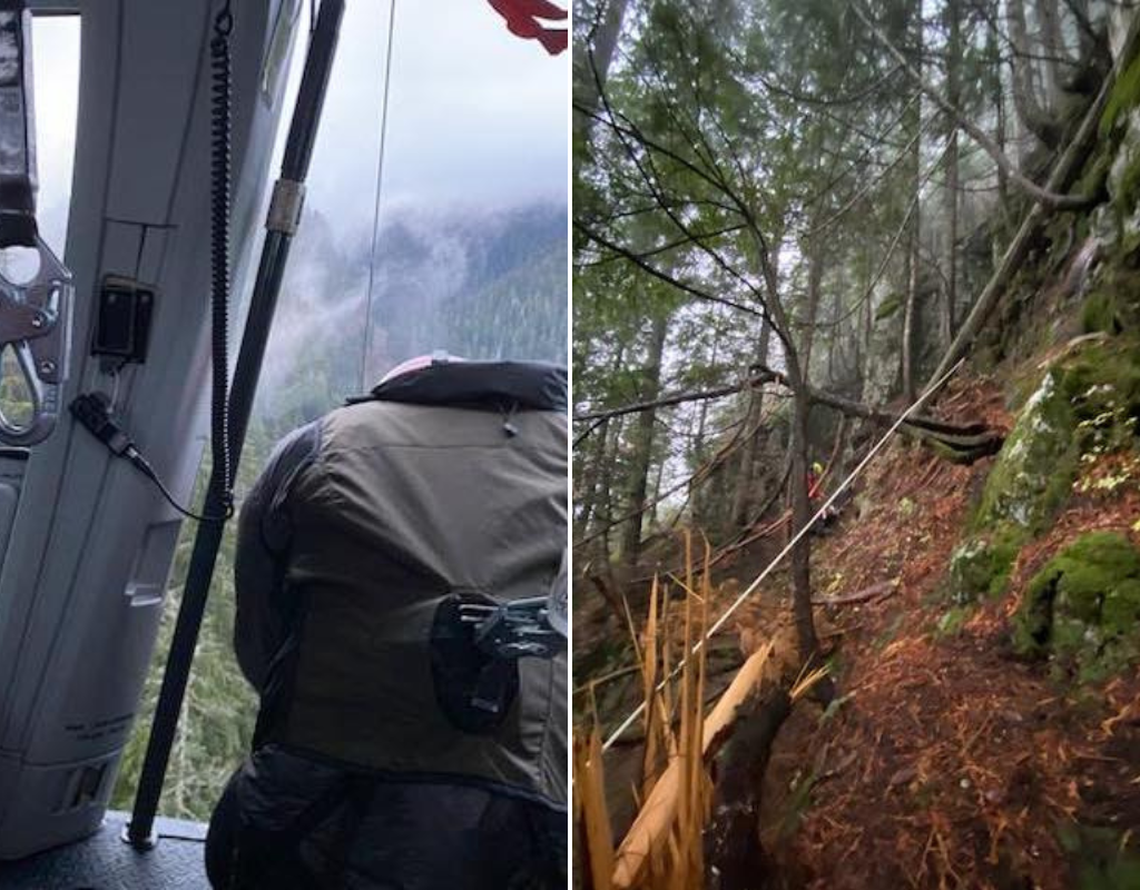
Rescuers had to race against time to locate the missing hiker before the low cloud cover made a helicopter airlift impossible.
The hiker did not have a flashlight on him so he could not be spotted from the air through the dense canopy. To search the area, two rescue technicians were lowered down and used a rope belay system to safely navigate the steep terrain.
“The team was able to locate the subject, get him in a harness, and bring him safely down to a location where he and the team could be extracted by helicopter – just before the clouds closed in and would have otherwise prevented helicopter access,” the group wrote on Facebook.
Just one month prior, the group had to rescue a different hiker from the same area.
North Shore Rescue wrote in September that it was called out for a rescue mission after a hiker phoned 911, saying he was stuck on a cliff on the north side of Mount Fromme and wasn’t sure how much longer he could hold on.
The sun had already set by this time, so a rescue crew equipped with night-vision goggles was deployed to the area via helicopter.
“During this time the subject phoned 911 again and said he was having difficulty holding on,” the group wrote.
The hiker was able to flag down the rescue helicopter using his phone flashlight and two rescue technicians were lowered down to his location. Rescuers placed the hiker in a harness and were able to hoist him back into the helicopter.


In the weeks after this rescue, North Shore Rescue said it placed warning signs in the area north of Mount Fromme warning that there are no trails. Apparently, the signs were not enough to prevent the second hiker from getting lost on Nov. 4.
North Shore Rescue said it tried to contact Google Maps to delete the non-existent trail but didn’t receive a response until Nov. 6. The rescue group thanked members of the community for reporting the phony trail and flagging the issue to Google.
The group writes that there are “a few ‘lessons learned’ from this situation.”
“First, it is simply not appropriate to navigate in the wilderness using ‘urban street map’ programs like Google Maps,” the organization states, recommending that hikers use programs specifically designed for the outdoors such as CalTopo or Gaia GPS.
North Shore Rescue also advises using a “good old fashioned paper map and compass” and encourages hikers to pack essential gear like an external battery, good footwear and a flashlight.
It’s unclear how the non-existent trail ended up on Google Maps.
In a statement to the New York Times, Google said: “We use a variety of sources to update Google Maps, including third party information, imagery and feedback from our community.”


Comments
Want to discuss? Please read our Commenting Policy first.