
The city is lush and green but you know what’s missing? Mosquitoes.

So far this spring we haven’t had a real rain storm in Winnipeg. May, in general was really dry (it was the driest May since 1992) and as much as we’ve seen rain on the weekends, we really haven’t had a lot of rain in general and certainly not a rainy week. This week will be rainy.
Monday will be nice but then we’ll start to get into the wet stuff.
Tuesday will likely see the most rainfall. There’s also a chance for severe thunderstorm activity here. Environment Canada is forecasting the chance of severe thunderstorms starting early Tuesday with a focus on southwestern portions of the province.
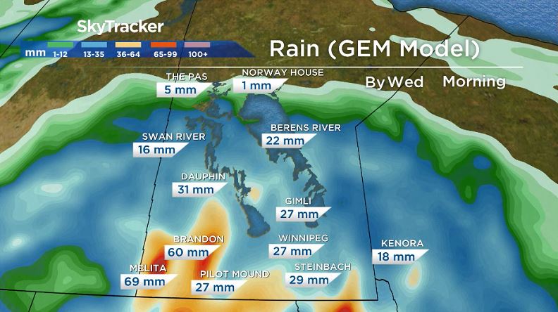
A general forecast for southern Manitoba on Tuesday would be rainfall amounts of 10-15mm with higher amounts up to 25mm possible with thunderstorms but as you can see in the tweet below, some models are seeing the possibility of higher amounts than 25mm.
Take this picture with a grain of salt. This is the GEM model’s attempt to indicate convection. With the chance of severe weather Tuesday, you can take away is the storm is likely to hit southwestern Manitoba and could, for the first time this year, bring heavy rain. Large hail and damaging winds are also possible so be aware when severe thunderstorm watches and warnings are issued for your area.


Wednesday is probably the only other day where severe weather could happen in southern Manitoba as the low pressure system will still be close by.
The rest of the week looks damp as well but not nearly to the same extent. There doesn’t look to be any heavy rain coming afterwards, just light rain on and off for the better part of the week.
Comments