

A rainfall warning ended for London and surrounding areas late Friday night, but forecasters say on-and-off showers are expected to continue through the day Saturday heading into the evening hours.

The lighter showers come on the heels of a storm system that dumped between 40 and 50 millimetres of rain across much of southern Ontario over the last 48 hours, according to rainfall measurements released by Environment and Climate Change Canada.
At London’s airport, 46.9 millimetres of rain fell between 9:30 a.m. Thursday – when showers started – and 6 a.m. Saturday, according to Rob Kuhn, a severe weather meteorologist with the national weather agency.
“London is pretty well right in the middle of the pack,” he said. “The Forest City got soaked like pretty well everybody else did.”
In Belle River, volunteers measured a total of 69.4 millimetres of rainfall as of 6 p.m. Friday. In Ridgetown, Harrow and Chatham, between 50 and 55 millimetres of rain fell as of 6 a.m. Saturday. Elsewhere, around 51.8 millimetres of rain was recorded in downtown Toronto.
“A large swath of regions got between 40 and 50 millimetres in about two days. That was very common,” Kuhn said.
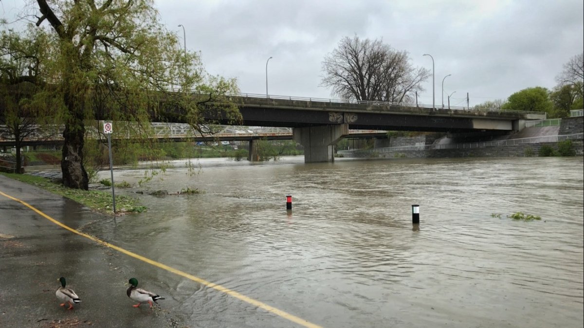
A flood watch from the Upper Thames River Conservation Authority (UTRCA) remains in place and is in effect until Monday. In an update on Saturday morning, the conservation authority said the local watershed had received about half the amount of rain that had been forecast at the start of the system.
Steve Sauder, a conservation authority spokesperson, said water levels recorded at the forks of the Thames River were more than two metres higher than normal for this time of year. The Thames River peaked upstream overnight and is expected to peak in the city during the day Saturday, Sauder said, adding flows will remain high through the weekend and through much of next week.
“Residents are reminded to use extreme caution near all watercourses, stay out of any flooded areas and to keep children and pets away,” a UTRCA media release said. “Streambanks are slippery and the water is cold and moving quickly.”


Due to the high water levels, the city has also implemented a boating ban on the Thames until levels decline. Municipal sports grounds – including soccer fields, baseball diamonds, and cricket pitches – are also off limits to the public until Monday.
Other local conservation authorities – including Ausable Bayfield, Catfish Creek, Long Point Region, Lower Thames Valley, Kettle Creek and St. Clair Region – also had flood watches in place as of noon Saturday.
A 60 per cent chance of showers will stick around through Saturday afternoon and evening, Kuhn said.
Environment and Climate Change Canada is calling for drier conditions on Sunday. London will see cloudy conditions, a 30 per cent chance of showers and a high of 6 C.
“Beyond that – finally – as we go into next week, Sunday night through Tuesday and Wednesday, it looks to be quite dry. Various mixes of sun and cloud, cool, below normal – but a slow warming trend up towards closer to normal later in the week,” said Kuhn.
The average high for this time of year is 18 C.
Comments