
Today’s 20 degree heat heads out with a cold front Tuesday night, but when will it return?

Saskatoon Forecast
Today
It was a much milder morning compared to yesterday when the mercury fell below freezing, with a low temperature only dipping back to 7 degrees today under clear skies.
By noon, we had risen into the low 20s in Saskatoon under a ridge of high pressure keeping us under mostly sunny skies right from the morning into the afternoon.
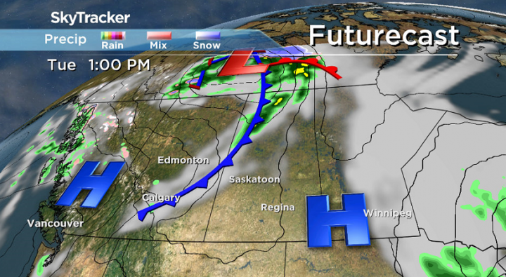
Tonight
An approaching cold front will stir things up into early this evening, picking up northwesterly winds to 30 km/h gusting upwards of 40 to 50 km/h at times and bringing in the clouds before conditions clear again overnight and temperatures drop back to just a few degrees above freezing.
Wednesday
Tomorrow will start off with some sunshine before a pulse of mid-level moisture pushes through bringing in the cloud cover midday and a chance of showers from the afternoon through the evening.
Behind the cold front, temperatures will also be much cooler, out of the low 20s and into the mid-teens for an afternoon high.

Thursday-Friday
Thursday will start out cloudier with some sunshine returning later in the day and an afternoon high pushing a bit warmer into the high teens.
Then on Friday as the upper ridge tries to rebuild, temperatures may top out as warm as 20 degrees under a mix of sun and cloud.

Weekend Outlook


The next system is set to move through this weekend to kickoff October!
Ahead of it, we’ll get a kick of heat for Saturday with a daytime high expected to be just into the low 20s under a mix of sun and cloud.
Then the cold front associated with that system slides through for the second half of the weekend on Sunday, bringing back more cloud cover, a good chance of rain and temperatures back into the teens.
Into the first week of October there is now more than one forecast model hinting at the potential for snow mid-week as a cool upper trough swings through dropping mid-level atmospheric temperatures below zero at a time when precipitation may form.

We’ll keep a close eye on this potential and bring you the latest on Global News at 6pm.
This Your Saskatchewan photo was taken by Susan Detillieux near Meacham:

Saskatoon weather outlook is your one stop shop for all things weather for Saskatoon, central and northern Saskatchewan with a comprehensive look at your local forecast that you can only find here.
- Posters promoting ‘Steal From Loblaws Day’ are circulating. How did we get here?
- Canadian food banks are on the brink: ‘This is not a sustainable situation’
- Video shows Ontario police sharing Trudeau’s location with protester, investigation launched
- Solar eclipse eye damage: More than 160 cases reported in Ontario, Quebec
Comments