
Thursday, July 21, 2016
Weather forecast update at 5:45pm:
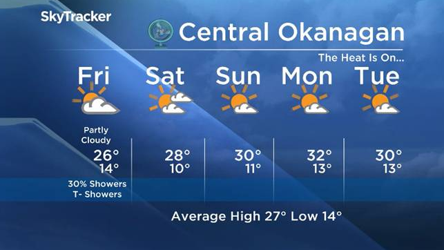
By now you are surely aware that the unsettled weather pattern normally associated with June, spilled over into the first 2 weeks of July.

The good news for sun seekers is that ends now…well with one small exception.
On Friday the remnants of the cool upper low that has caused cloud, suppressed daytime highs and the risk of thunderstorms, will make a last kick at the can before moving east out of the Okanagan. Although the highest probability for showers or thundershowers on Friday will occur east of the Okanagan from Grand Forks north up through the Arrow Lakes region, there is a slight possibility for the Okanagan.
Don’t be discouraged though, it will be short lived and the weekend will blossom into sunny days with temperatures hovering around the 30C mark.


Make outdoor plans !
Friday’s daytime high range: 21 to 28C
We will have the rest of your weather details coming up at 5pm and 6:30pm and 11pm – Hope you can join us!
~ Duane English / Wesla Wong
Comments