
On Google Maps, it’s not uncommon for people to see what an area looked like two, four, or even eight years ago.

But if you’re interested in seeing what a highway in British Columbia looked like, you can go back 50 years.
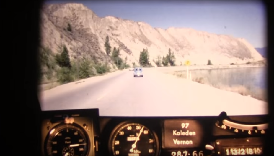
Two employees with the Ministry of Transportation have been posting a series of “RoadTrip Time Machines” on YouTube, allowing British Columbians to see what the busiest corridors in the province looked like in 1966.
WATCH: Highway 97, Penticton to Kelowna
The series shows photos every 80 feet from the dash of a 1966 Ford Falcon, sped up so that the entire highway is crossed in minutes.
“We thought it was really interesting, but we didn’t know what other people would think,” said Kristen Reimer, who does online communications for TranBC.
“It’s something we’ve been doing on the side. We love it, and I think it’s fascinating.”
For decades, the ministry has run a photo log program, ensuring that engineers and other experts can see the conditions on and around highways without having to be at the scene. But the footage shot by the Falcon hadn’t been used for decades, until Reimer and James Penner, who also works in the ministry, found out the tapes went back 50 years.
“We thought we gotta get our hands on it,” said Reimer. “It would be so amazing to see what our province looked like in the 60s.”
They uncovered a musty box packed with 16mm film, and used time off work to find old projectors and lightbulbs to play the video and digitally convert it.
“We looked into having someone do it professional, but it would have cost an arm and a leg,” says Reimer.
WATCH: Highway 99, Horseshoe Bay to Squamish


The 13 road trips include the Sea-to-Sky Highway from Vancouver to Whistler when it was just a rickety two-lane highway, the Malahat from Victoria to Duncan when it was just a rickety two-lane highway, and Highway 97 from Penticton to Kamloops, when it was just a….well, you get the idea.
(For the full list of “road trip” videos, click here)
“What I notice a lot is wherever possible we’ve widened the roads,” says Reimer.
“In the 60s, there’s a lot of people doing pull-arounds, they are taking lots of chances…we’ve widened the road wherever possible, and kept travellers safe, so they don’t have to make those risky moves. And it’s amazing how much townsites have grown. Some people have a hard time identifying where they are because it’s grown so much.”
Yesterday, they posted a new road trip, on Highway 1 from Lytton to Revelstoke – and they’re looking forward to posting more in the months ahead.
Comments