
As Hurricane Joaquin makes its way northward, there are many Americans who are likely breathing a sigh of relief.

Initial forecasts had Joaquin tracking towards the Carolinas after weakening from a major hurricane (Category 3 or higher) but still as a hurricane, nonetheless.

“This was not an easy storm. The weather patterns around it made it very complex,” Dennis Feltgen, a meteorologist with the National Hurricane Center (NHC) told Global News. “Things change as the event evolves.”
Feltgen said that the cone of uncertainty the NHC has in its forecast illustrates the difficulty with trying to forecast so far in advance. “Two out of three times, the hurricane falls within that cone,” he said. “That means that one out of three it doesn’t.”
READ MORE: Hurricane Joaquin churns up Joaquin Phoenix memes on social media
Fortunately for eastern seaboard residents, the track seems to be keeping the storm off the coast.
Things could have been far worse. It could have been more reminiscent of Hurricane Sandy.
Looking back at Hurricane Sandy, which devastated New Jersey and New York in October 2012 as a tropical storm, it’s a lucky thing Joaquin seems to be headed on a northeast track.
Unlike Joaquin, though, Sandy was an enormous hurricane. At one point, Sandy’s tropical storm winds stretched out 1,000 miles from its 50-mile-wide eye. In comparison, Joaquin’s tropical winds extend 300 miles from its 23-mile-wide eye.
Sandy caused widespread flooding and damage along its path, ultimately costing Americans about $75 billion. It was the second most costly storm in U.S. history.

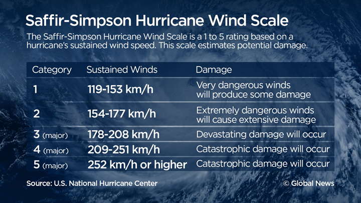
Joaquin is still a major hurricane, with winds of 215 km/h, a Category 4 on the Saffir-Simpson scale.
It will likely remain as a major hurricane until late Saturday or early Sunday as it heads towards the northeast, after which it will weaken. It is forecast to remain a hurricane as it turns more to the east on Tuesday, off the coast of Nova Scotia. By Wednesday, as it passes off the shores of Newfoundland, it will weaken to a tropical storm.
So it’s good news that there won’t be another Sandy.
“Both the U.S. and Canadian provinces will be spared, which is a very good thing,” Feltgen said.
“The only indirect effects will be increased surf and riptides.”
Keep track of Hurricane Joaquin with Global’s new SkyTracker app, available for iOS and Android devices.
Comments