

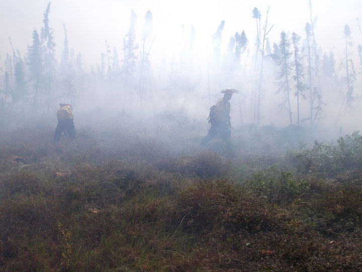
WATCH ABOVE: Crews in British Columbia battle wildfires in Red Deer Creek.

TORONTO – In a country that boasts 396.9 million hectares of forest and wooded land, accounting for 39 per cent of our total land area, fighting forest fires can present its challenges.
“The challenge of fires is always really big for us in Canada, but we’re doing a really good job,” Bruce McNabb, head of Wildland Fire, Information Systems at the Canadian Forest Service said.
As of Friday, more than 2,500 fires had burned across Canada, accounting for 1,066,022 hectares of forest. Believe it or not, though, that’s good news: that’s almost 1,000 fewer forest fires that were burning this time last year. By July 11, 2013, 2,248,010 hectares had burned, more than a million in Quebec alone.

READ MORE: Smoke blankets Saskatoon, lowering air quality
The worst spot this year is the Northwest Territories with more than 842,000 hectares burning. In Saskatchewan, more than 64,000 fires are burning, and in British Columbia more than 11,000 hectares are up in smoke.
But the fires aren’t just relegated to the west. While Ontario is experiencing a quieter fire season than normal – thanks in part to a cold and snowy winter and a slow start to spring – Quebec has seen more than 35,000 hectares burn.
Tools of the trade
Each province and territory is responsible for fighting forest fires, and the tools they use range from satellites to planes. Though there has been talk in the United States about using drones to pick out forest “hotspots” – areas that look to be burning – it isn’t something that is being considered yet.
- Canadian man dies during Texas Ironman event. His widow wants answers as to why
- ‘Shock and disbelief’ after Manitoba school trustee’s Indigenous comments
- Canadian food banks are on the brink: ‘This is not a sustainable situation’
- Invasive strep: ‘Don’t wait’ to seek care, N.S. woman warns on long road to recovery
Judy McLinton, manager of Public Affairs and Communications for Environment and Natural Resources for the Government of the Northwest Territories, said that drones may not be that useful.
“Drones have not been considered and would probably not be that effective given there is about 33 millon hectares of boreal forest in the Northwest Territories and only 33 communities,” said McLinton.
But that doesn’t mean that they don’t consider new technologies.
“We are always looking and assessing new technologies to help protect our forest resources from fire,” she said.
“In general, there are lots of ways that people detect fires… Probably the number one method – especially in Canada’s north – is hotspots satellite imagery.”
The satellite imagery that is mostly used is from the U.S. MODIS instrument.
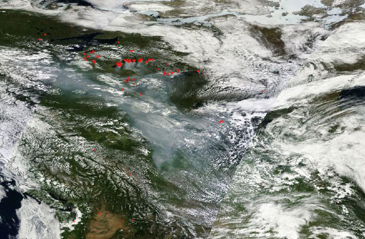
The Moderate Resolution Imaging Spectroradiometer lives aboard the Terra and Aqua (Terra passes from north to south in the morning; Aqua from south to north in the afternoon). The instrument is able to detect hotspots around the globe.
Various provincial forest fighting agencies use the data collected to establish where they need to pay specific attention or send out crews.
“Canada is widely considered to be a leader in forest fire management, and that’s not just a statement,” said McNabb. “The Canadian Forest Fire Danger Rating system is the standard in the world. It’s being used in Mexico, parts of the U.S., New Zealand, Fiji, the European Union, Malaysia.”
“Other nations look to us, generally, on preparedness.”
The rating system collects data from various sources. Some fires will burn themselves out or may not pose a danger to a population and public assets.
The data collected falls into five general categories: fuels, weather, topography, foliar moisture content (how much moisture is in the leaves and pine needles), and type and duration of prediction.
In using this data, managers of various fire agencies determine the areas that are most vulnerable to fires and also decide where best to utilize their resources.
As for future technologies to fight fires, McNabb said that everything is open, but that right now the agency is aiming to produce even better tools.
But other tools are also available to provinces – like social media.
“We’re a pretty active organization on social media,” Kevin Skrepnek, provincial fire information officer for the B.C. Wildfire Management Branch said. “And we…certainly utilize things like Twitter, like tracking down photos that people are posting. Often we’ll have that before our crews are on site. So that can help with our operational decisions as well.”
The great thing is that cellphones often provide GPS co-ordinates which can help firefighters pinpoint exact locations.
Skrepnek said that they also use the Canadian Lightning Detection Network provided by Environment Canada. This helps them get an idea where lightning may spark fires in vulnerable areas.
But there’s always room for improvement, McNabb said.
“What we’re really focusing on is better predictive tools, like fire-growth modelling,” McNabb said.
Utilizing more than 1,800 weather station across the country, as well as smoke modelling technology, the Canadian Forest Service aims to be even better prepared to determine where fires – as well as dangerous smoke – may move.
McNabb is proud of how the provinces tackle fire management with the existing tools.
“We have about two million hectares of forest burned a year, and…fatalities are very, very, rare, so we’re doing something right.”
Comments