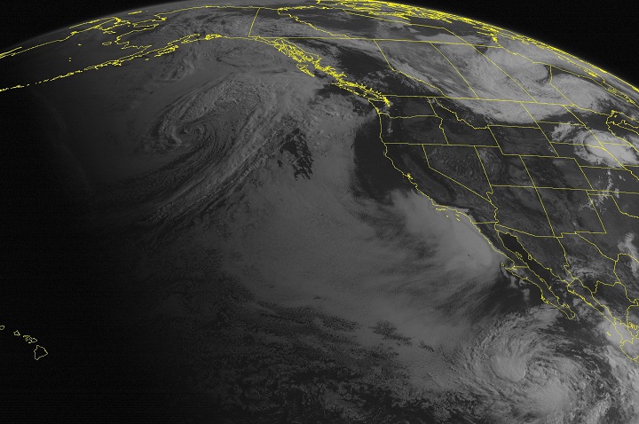
MIAMI – Tropical Storm Elida formed Monday off the southwestern coast of Mexico, generating dangerous ocean surf and heavy rains.

Elida was centred Monday afternoon about 195 kms off the coast of Manzanillo, Mexico, said the U.S. National Hurricane Center in Miami.
It had maximum sustained winds of 85 kph, and was moving northwest at 12 mph (19 kph), parallel to the coast, the centre said. The storm was not expected to strengthen much over the next two days, and was forecast to slow down substantially by Tuesday morning. The Hurricane Center said Elida would likely change course and move toward the west-southwest through Wednesday, staying near but off the coast of southwestern Mexico.
A tropical storm warning was in effect Monday from Lazaro Cardenas to Cabo Corrientes.
Elida was expected to dump 3 to 6 inches (8 to 15 centimetres) of rain over western portions of the Mexican states of Colima and Michoacan and over the southwest portion of Jalisco, with a maximum of 8 inches (20 centimetres) in some of those areas. The storm also was generating heavy ocean swells that the centre said are likely to cause life-threatening surf and rip currents.

A second tropical storm, Douglas, was also swirling in the Pacific off the Mexican coast, but did not pose any hazards to land as of Monday afternoon.
Douglas, with maximum sustained winds of 40 mph (65 kph) was located about 465 miles (745 kilometres) southwest of the southern tip of Baja California state and was moving northwest at about 9 mph (15 kph). Some strengthening was possible over the next couple of days, the Hurricane Center said.
- Posters promoting ‘Steal From Loblaws Day’ are circulating. How did we get here?
- Video shows Ontario police sharing Trudeau’s location with protester, investigation launched
- Canadian food banks are on the brink: ‘This is not a sustainable situation’
- Solar eclipse eye damage: More than 160 cases reported in Ontario, Quebec
Comments