NEW YORK – The spotting of ocean debris by satellites during the search for the lost Malaysian airliner has drawn attention to those orbiting platforms. A primer on what’s in orbit, with help from Nicholas Johnson, who retired Thursday as NASA’s chief scientist for orbital debris:

HOW MANY SATELLITES ARE UP THERE?
About 1,100 active satellites, both government and private. Plus there are about 2,600 ones that no longer work. Russia launched the first satellite, Sputnik 1, in 1957. The oldest one still in orbit, which is no longer functioning, was launched in 1958.
READ MORE: Flight MH370: Canadian pilot helps in search for lost Malaysian Airlines jetliner
HOW BIG ARE THEY?
Size varies. Communication satellites can be as big as a small school bus and weigh up to 5400 kg, the Federal Communications Commission says. Most weigh a few tons or less. Some that are used briefly are four-inch cubes and weigh about 1 kg.

WHAT EXACTLY DO THEY DO?
They have a wide variety of roles: GPS satellites aid navigation, others relay telephone or television signals, others aid in weather forecasting, national defence, science, and agriculture, as in monitoring crops and areas of drought. The Union of Concerned Scientists, a private organization that maintains a database of satellites, says about 60 per cent are used for communications.
WHERE ARE THEY?
It depends on their use. Communications satellites relay signals from a fixed spot on the equator, about 35,000 km up. GPS satellites are at 20,000 km up, high enough to be accessible to large swaths of the Earth. Others that need a closer look at Earth are lower. For comparison, the International Space Station is only about 418 km high, and very few satellites are lower than that. While some satellites remain over fixed spots on Earth, others fly over both poles or can move from place to place as needed.
READ MORE: Flight MH370: U.S. company provides Australia satellite imagery of possible debris
HOW HAVE THEY HELPED IN THE SEARCH?
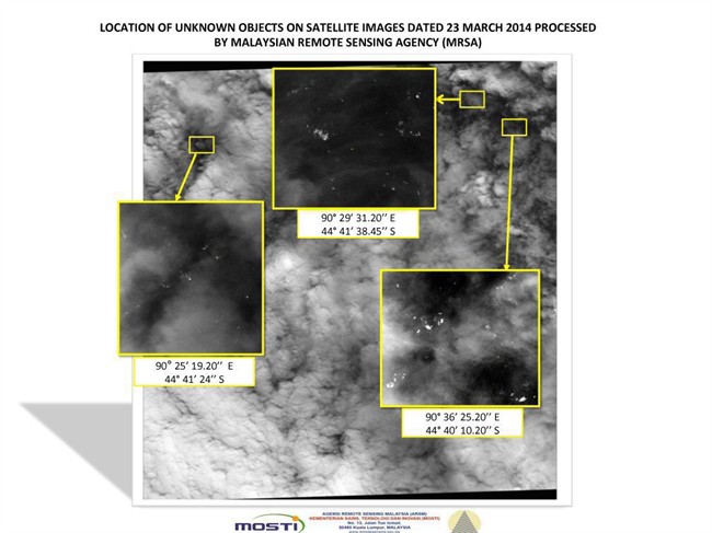
A British communications satellite picked up signals from the plane; analysis of them led authorities to conclude that the airliner crashed in a remote area of the southern Indian Ocean. This week, Thai authorities said one of their satellites spotted 300 objects that might be from the airliner. Some satellites were moved into place to look for debris.
WHO OWNS THEM?
Governments large and small, and private companies. More than 50 countries own a satellite or a significant share in one, according to the Union of Concerned Scientists. There are 502 active satellites with a U.S. tie; 118 for Russia and 116 for China. Thailand has four satellites and shares in another, the scientist group says.
WHAT IF THEY STOP WORKING?
Old satellites can pose a risk for collisions with active ones, so there are rules and recommendations to avoid a buildup of junk in space. Satellites that fly below a certain height are supposed to be put in an orbit that will make them fall to Earth and burn up within 25 years. At high altitudes, they are to be boosted up to still higher orbits to get them out of the way.
— Online: NASA satellite tracker: http://1.usa.gov/1dyKhCd
Comments