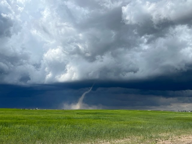
Environment Canada said the weather is setting up to produce funnel clouds across a swath of central Alberta and the Edmonton area on Wednesday, although the conditions aren’t expected to be severe enough to produce super-cell tornadoes.

A cold front coming is coming in from B.C., bringing with it unstable atmospheric conditions.
“We expect some vigorous cumulus clouds — so those white fluffy clouds — which could lead to some weak funnel clouds forming,” Environment Canada meteorologist Sara Hoffman said.
Hoffman said the conditions Wednesday mean there could be quick growth of clouds and some spotty showers or weak thunderstorms — but they could also dissipate as quickly as they form.
“Folks will likely see it and they might get scared,” she said. “But we’re not expecting widespread, significant impacts from this weather at all.”
A weather advisory was issued just before noon, saying funnel clouds are possible from near noon until early in the evening south of Edmonton and north of Calgary.
It was later expanded to include areas surrounding Edmonton, such as Parkland County to the west and Sturgeon County to the north.
The advisory may be extended to the east towards Saskatchewan as storms forming in the foothills make their way across the Prairies.
Severe thunderstorm watches were later issued for the eastern side of central Alberta.
“Thunderstorms are developing in western Alberta. As these thunderstorms track to the northeast, some of them may become severe between this afternoon and later this evening,” an update said.

Get daily National news
Hoffman said Wednesday’s weather may, at the worst, produce a landspout tornado — twisters triggered by thunderstorms that develop quickly and are generally smaller and weaker than supercell tornadoes.
“If (landspout tornadoes) were to form, they’re usually short lived and quite weak,” Hoffman said. “But I would still advise keeping your distance and reporting it when it’s safe to do so.”

Environment Canada said in order for a severe thunderstorm or supercell tornadoes to form, three things are needed: moisture, wind shear and atmospheric instability — and on Wednesday, only the latter is really notable.
“We have the moisture, but it’s not nearly as high as it would be on a severe thunderstorm day. And we might have a little bit of shear, but it’s not nearly as high or as big a factor as it would be on a severe thunderstorm day,” Hoffman said.
- False spring strikes again: Saskatchewan prepares for incoming winter weather
- Albertans’ interest in alternative forms of travel growing as fuel prices spike
- Massive avalanche closes Alberta’s Icefields Parkway until at least Saturday
- 13 years after Calgary’s devastating flood, 6 riverfront properties are for sale
“So, we do have the instability, but we the other two key ingredients are kind of lacking.”
Hoffman also dispelled a common belief that hot days are required for severe summer weather to develop in Alberta.
“A common misconception is that you need high temperatures for the formation of a severe thunderstorm. That’s not true at all. We have had instances where supercells have formed at very cool temperatures like mid-teens to high teens degrees for daytime highs,” she said.
Hoffman explained atmospheric instability is key: colder air higher up over warmer air at the surface of the earth.
“They just need to be relatively cooler and warmer compared to each other. They don’t have to be cool or warm by our standards, if that makes sense,” she said
“If Environment Canada is saying there’s severe thunderstorms and it’s feeling cool to your outside, you still listen because it’s totally, entirely possible to still form.”
If you do spot severe weather — tornados forming, hail larger than two centimetres, wind gusts exceeding 90 km/h — your are encouraged to report it to Environment Canada.
To report severe weather to the government agency, send an email to Abstorm@ec.gc.ca, call 1-800-239-0484 or share on Twitter/X with the hashtag #ABStorm.


Comments
Want to discuss? Please read our Commenting Policy first.