

A snowfall warning has once again been issued for Metro Vancouver, the Fraser Valley and parts of Vancouver Island Monday.

Environment Canada issued the warning for Metro Vancouver, Greater Victoria, Malahat Highway – Goldstream to Mill Bay, Fraser Valley, Sunshine Coast – Gibsons to Earls Cove, Southern Gulf Islands, East Vancouver Island – Duncan to Nanaimo, East Vancouver Island – Nanoose Bay to Fanny Bay, West Vancouver Island, and inland Vancouver Island.

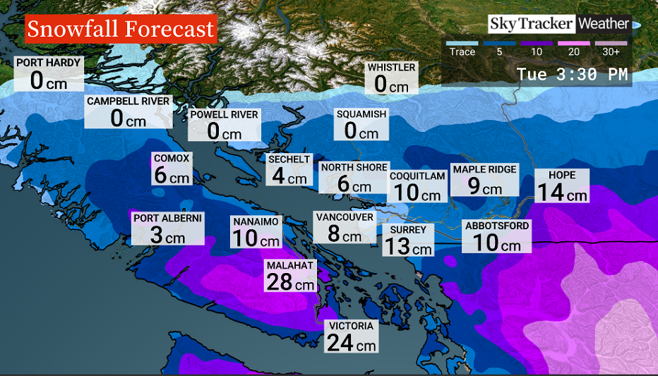
Starting Monday night, Environment Canada says between 10 and 15 centimetres is expected for most regions but up to 20 centimetres could fall in Victoria, on the Malahat Highway, the Southern Gulf Islands, Lake Cowichan, Port Renfrew, and East Vancouver Island from Duncan to Fanny Bay.
Snow will taper off late Tuesday morning on Vancouver Island and Tuesday afternoon on the mainland side, Environment Canada said.
This snow comes after heavy snow fell across the region on Sunday, followed by plunging temperatures.


Bitterly cold Arctic air resides over British Columbia and will hold for several days, Global BC meteorologist Mark Madryga said.
In the Interior, temperatures under a clear sky have fallen to nearly -40 C in the Cariboo-Central Interior, with some even lower, such as the Puntzi Mountain weather station in the Chilcotin, which fell to -47 C. That converts to 53 below Fahrenheit, Madryga added.
- 28K Manitoba Hydro customers without power after storm causes ‘extensive damage’
- France lets 84K evacuees go home as wildfires spread across Europe
- Death toll from earthquake in Japan rises to 25 as rescue hopes dwindle
- Hikers evacuated from West Coast Trail as Parks Canada says parts are impassable


An incoming Pacific front will bring the snow to the region and Madryga said the snow will ease Tuesday morning as the system moves to the east.
“Even colder air will follow on Wednesday and Thursday morning in the Lower Mainland before the next weather system spreads in more snowfall on Friday,” Madryga added.
Comments
Want to discuss? Please read our Commenting Policy first.