

Prepare for cold weather. In some parts of B.C., make that bitterly frigid weather.

Environment Canada has issued weather warnings for several regions across the province, ranging from northern B.C., along the Yukon border, to some coastal sections.
The warnings all stem from an arctic front with strong winds that’s moving south.
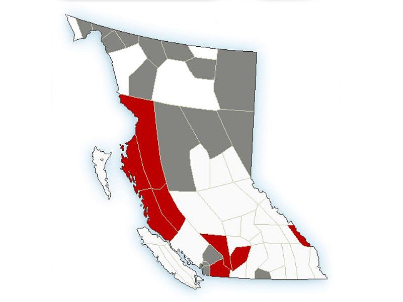
Starting near the Yukon border, special weather statements for bitterly cold temperatures are in effect for many areas, including the Fort Nelson, Peace River and Williston regions.
The forecasts differ slightly for those areas, but, generally, Saturday will see a high of around -20 C with that dropping overnight to -25 C.
From Sunday to Thursday, highs will range between -25 C to 30 C, with overnight temperatures between -32 C and -38 C.
Along the Central Coast, arctic outflow warnings are in effect.

Get breaking National news
“Arctic air has infiltrated northern B.C., including the coastal areas,” said Environment Canada.
“Strong winds will combine with low temperatures to give wind chill values near -20 for inland sections of the North and Central Coasts. Along coastal regions, the winds will accelerate and reach near 80 km/h through the coastal inlets and valleys.”

Elsewhere, an extreme cold alert is in effect for Yoho Park and Kootenay Park along the border of B.C. and Alberta.
Environment Canada says a prolonged period of unseasonably cold temperatures are in the forecast this weekend, and most of next week, as a very cold arctic air mass settles over the region.
Temperatures will be around -25 C, though gusting northeast winds between 30 and 50 km/h will result in wind-chill values near or below -35 overnight Saturday and into Sunday.
The projected windchill for Monday through Friday: an even colder -40.


On top of that, there could be an additional 5 to 10 cm of snow on Saturday.
“Come Sunday night, winds will slightly ease but temperatures will plummet into the -30s every night with little reprieve each afternoon until Friday,” said Environment Canada.

The national weather agency reminds people that extreme cold puts everyone at risk and that frostbite can develop within minutes on exposed skin, especially with wind chill.
Lastly, Metro Vancouver and the Sea to Sky Highway are under special weather statements for a wintry mix of rain and snow, strong winds and cold temperatures.
“(Saturday’s) precipitation will fall as light flurries or showers depending on temperature and elevation,” said Environment Canada.
“In general, 2- 4 cm of snow can be expected across the region. For Metro Vancouver, snowfall accumulations are mainly expected over higher terrain.
“With the passage of the arctic front on Sunday, strong outflow winds will bring in cold arctic air and temperatures falling 5 to 10 degrees below seasonal average. Wind chill values will approach -10 to -15 in Metro Vancouver by late Sunday, and -15 to -20 in the Fraser Valley and Sea to Sky region.
In the eastern part of the Fraser Valley, strong outflow winds are in the weekend forecast, as is 15 cm of snow by Sunday afternoon.

Comments
Want to discuss? Please read our Commenting Policy first.