

An incoming atmospheric river is expected to soon drench and blanket parts of B.C. with heavy rain and snow.

On Wednesday morning, Environment Canada issued special weather statements for heavy rain for the South Coast, along with snow at higher elevations.
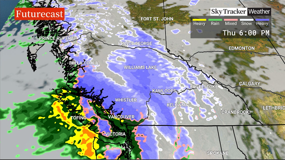
For B.C.’s Interior, a large swath is under a special weather statement for 10 to 20 centimetres of snow.
The atmospheric river is expected to begin Thursday afternoon, then taper off by Friday afternoon.
South Coast regions under special weather statements include Metro Vancouver, the Fraser Valley, Howe Sound, Whistler, the Sunshine Coast, Victoria, the southern Gulf Islands and east Vancouver Island.
Total rainfall amounts of 30 to 70 millimetres are expected for lower elevations. Water pooling on roads is likely. Higher elevations, like Whistler, will see 10 to 20 centimetres of snow.
Snow is also possible on local mountains, Westwood plateau, SFU and the Malahat, as the overnight freezing level is expected to drop to around 300 metres.
“Wind will also accompany the storm,” predicts Environment Canada. “Strong southeasterlies of 40 to 60 km/h will develop through the Strait of Georgia on Thursday afternoon. The winds will shift to strong west and northwesterlies of 40 to 60 km/h on Friday.”
The national weather agency noted that Victoria could see westerly winds gusting to 80 km/h Friday afternoon before easing that evening.

For Friday, with freezing levels climbing to around 2,000 metres, a rise in streams and rivers is expected, and minor flooding is possible.
Notably, the incoming atmospheric river is classified as being a Level 2 or 3. The last two storms were classified as Level 1 or 2.

Get breaking National news
A two classification means a storm could be mostly beneficial, but also hazardous. A three classification means the storm could be a balance of beneficial and hazardous.
For Whistler, the snow is projected to start falling Thursday afternoon, with moderate gusty winds reducing visibility.
For Friday, freezing levels are expected to rise to 2,000 metres, changing the snow to rain, though freezing levels are expected to plummet to the valley bottom on Saturday morning.

Elsewhere, special weather statements for 10 to 20 centimetres of snow are also blanketing a large swath of B.C.’s Interior — from the North Thompson in the south to the Peace River and Bulkley Valley regions in the north.
“A frontal system associated with an atmospheric river will produce heavy snowfall rates across the central interior beginning Thursday afternoon,” said Environment Canada.


“Strong south to southeast winds of 30 km/h gusting to 60 km/h will accompany the snow. Travellers are advised to check their travel plans and be prepared for poor visibility in heavy snow and/or blowing snow.”
The snow will end Thursday overnight or early Friday morning, as rising freezing levels cause precipitation to transition to rain.

The Interior — including the Sea-to-Sky from Brandywine to Pemberton, the Cariboo, 100 Mile House, North Thompson, Prince George and communities along highways 16 and 97 in northern B.C. — could experience the worst conditions.
Along with the 10-20 cm of snow, strong winds of 60 km/h are expected, and travel is not recommended due to snow and low visibility.
“All of the Interior regions, including the Sea-to-Sky from Brandywine to Pemberton, which are under a special weather statement at this time, will experience dangerous conditions on the roads and a massive swing in weather conditions over the next two days,” said Global News meteorologist Kristi Gordon.
It’s possible the special weather statement could change to a snowfall warning, then transition to a rainfall warning.
With warmer conditions expected Friday, Gordon says elevations up to 2,000 metres could experience rain, which means low-lying areas could face runoff after heavy rain and significant snowmelt.
Lastly, snowfall warnings are in place for the East Kootenay and Elk Valley regions, where five to 10 centimetres are expected to fall Wednesday.

Comments
Want to discuss? Please read our Commenting Policy first.