

After weeks of soggy weather, and B.C. residents wondering when summer will arrive, Mother Nature is turning up the thermostat.

On Wednesday, Environment Canada issued special weather statements for nearly every region of the province, with temperatures expected to rise to the low and mid-30s.
The warnings stretch from eastern Vancouver Island to the Lower Mainland to the Kootenays, through the Cariboo and into northeast B.C.
The only areas where there aren’t special weather statements are the Central and North Coast, Haida Gwaii and northwest B.C.
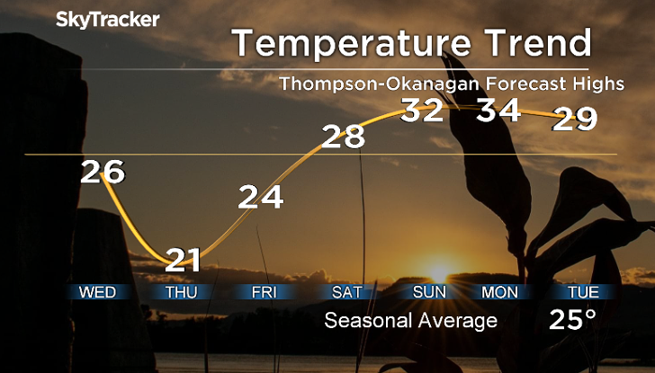
“The B.C. Interior will experience its first stretch of warmer-than-average temperatures beginning this weekend,” said Environment Canada.
“On Saturday, temperatures will reach into the upper 20s. For the remainder of the weekend and early next week, temperatures will rise into the low to mid-30s. Overnight lows will fall to the mid-teens.”

Get breaking National news
The national weather agency says as such, there will be an increase in snowmelt and snowpack instability, and that increased stream flows due to run-off are possible.

For the South Coast and Vancouver Island, daytime highs are expected to reach the upper 20s, with overnight lows into the mid-teens.
“On Friday, inland temperatures will reach into the mid to upper 20s,” said Environment Canada.
“Through the weekend and into early next week, temperatures will remain in the upper 20s until Tuesday. There will be some respite from the elevated daytime temperatures as overnight lows fall into the mid-teens.”
One year ago, a heat wave was scorching B.C., with temperatures in the high 30s. At the end of June and into early July, a heat dome had settled over the province, with temperatures reaching the mid-40s and even higher in some areas.


This week’s weather pattern will be different from the one that cooked B.C. in 2021, with temperatures nowhere near as hot. It’s also expected to move out quickly.

“A rapid shift to sunnier, dry and most importantly, hotter weather is on the way to most of British Columbia,” said Global BC chief meteorologist Mark Madryga.
“An upper-level, high-pressure ridge will steadily build on Thursday along the B.C. Coast, and will expand into the B.C. Interior on Friday. With the ridge, daytime temperatures will steadily increase and will likely peak over the three-day period of Saturday through Monday.
“Special weather statements have been issued by Environment Canada for the majority of the province as a lead-up and a definite ‘heads’ up’ of the major change in the weather that is certain to occur in the coming days.”

Madryga says the significant increase in temperature, and the sustained heat over this period, will further enhance the flooding potential, due to rapid high mountain snowmelt.
He added that this coming stretch of hotter weather is a fairly common occurrence at this time of the year.
Madryga says temperatures are expected to soar into the 30-degree ballpark in areas away from the ocean on the South Coast and in many Southern Interior areas, while Central Interior regions will experience highs into the mid to upper 20s.
“In contrast, last year’s record late-June heat event was under a much stronger, longer-lived, high-pressure ridge,” he said, “when temperatures topped 40 degrees on parts of the South Coast and soared into the upper 40s across the Southern Interior, setting all-time national temperature records.”
Comments
Want to discuss? Please read our Commenting Policy first.