

Residents of a large swath of British Columbia will want to keep their winter wear out a little longer, with another blast of icy weather in the forecast.

Global BC meteorologist Kristi Gordon said a cold-weather system was making its way across B.C. from north to south on Wednesday.
“As artic air remains entrenched across the region snow is possible over all elevations,” Gordon said.
“Much of the Interior can expect minimal amounts from a trace to a couple of centimeters. However, the Chilcotin region could see up to 10 centimeters by morning.”
Environment Canada issued a snowfall warning for the Chilcotin region, stating the heaviest precipitation was expected Wednesday afternoon and set to taper off into the evening.
Gordon said the weather system will also likely deliver a few flakes across the South Coast, though snow is not expected to stick in most regions.

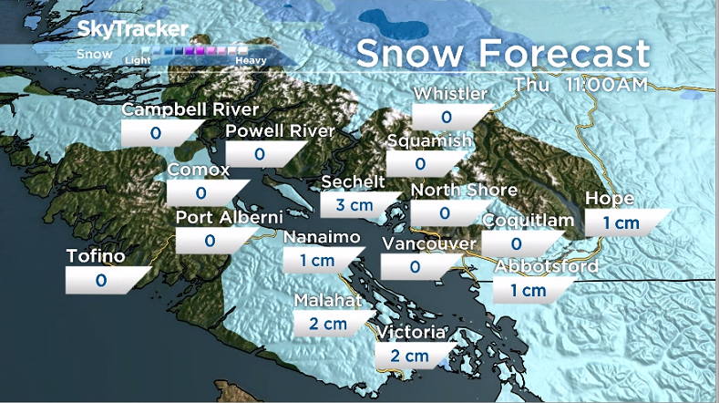
“The best chance for a couple of centimetres of snow by morning will be from Nanaimo down to Victoria and in the Southern Gulf Islands,” Gordon said.
However, while snow may not be an issue for drivers, Metro Vancouver, the Fraser Valley and the Howe Sound region were under a special weather statement from Environment Canada on Wednesday due to anticipated plunging temperatures.

Get breaking National news
The national weather and climate agency said overnight temperatures were expected to fall to between -5 C and -10 C at night, with temperatures warmer but still below seasonal averages during the day.


Environment Canada said light easterly outflow winds could result in wind chill values near -10 C to -15 C at night.
“Be prepared for cold temperatures. Dress warmly in layers, if outside. Ensure that shelter is provided for pets and outdoor animals,” it said.
Environment Canada also recorded more than a dozen cold temperature records for Feb. 23.
A gradual warming trend is forecast to begin on Thursday.


Comments