

Newly released satellite photos of the Pacific nation of Tonga depict a scene of vast devastation, showing the aftermath of a violent undersea volcano eruption and subsequent tsunami near the islands over the weekend.

A thick blanket of ash coats Tonga’s main island of Tongatapu, wiping out any traces of green previously captured on satellite images.
Aerial and satellite photos released by New Zealand, Australia and UNOSAT, the United Nations satellite centre, also show water damage and wrecked buildings after the volcano triggered massive tsunami waves that rapidly spread around the globe.
While some waves were reported to be approximately 80 centimetres in height, others reached far greater size, some as high as multiple metres.


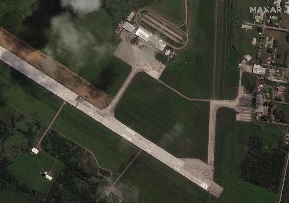
The ash has contaminated the island nation’s water supply. New Zealand’s military is sending much-needed drinking water and other supplies. However, thick ash on the airport runway has delayed deliveries and the first flight with supplies has been delayed by at least a day.
New Zealand is also sending two ships to the area with water supplies, survey teams and a helicopter, reports the BBC.
The volcano cut off much of the island’s telecommunication infrastructure. It’s believed that the underwater fibre-optic cable that tethers Tongo to the outside world was severed in the eruption. Also worrying is devices that could warn of further eruptions were damaged.
Little appears to be left of Hunga-Tonga-Hunga-Ha’apai, the exact island where the volcanic eruption happened on Saturday. Satellite images show only a small amount of land remains above water.

Despite the startling satellite images, Tonga appears to have avoided the widespread devastation that many initially feared.
- Nicolas Maduro to face trial on U.S. drug trafficking charges in June 2027
- Saudi Arabia nuclear pact with U.S. may create path to uranium enrichment
- Toronto pro-Palestinian protester charged with terrorism over alleged Hamas links
- Adolf Hitler’s birthplace in Austria is now officially a police station


Get breaking National news
“We did hold grave fears, given the magnitude of what we saw in that unprecedented blast,” said Katie Greenwood, the head of delegation in the Pacific for the International Federation of Red Cross and Red Crescent Societies. “Fortunately, in those major population centres we are not seeing the catastrophic effect we thought might happen, and that’s very good news.”
That said, there are still islands that have been cut off from all communication, leaving aid workers worried.
“There has been no contact from the Ha’apai Group of islands, and we are particularly concerned about two small low-lying islands — Mango and Fonoi — following surveillance flights confirming substantial property damage,” U.N. spokesperson Stephane Dujarric said.
Greenwood says that aid to the islands will have to be strategic. Tonga is one of the few remaining places in the world that has avoided any outbreaks of COVID-19, and they do not want a flood of aid workers coming into their communities and bringing the virus with them.
Red Cross officials estimated 50 homes were destroyed on Tonga’s main island, where U.N. and Tonga officials reported “significant infrastructural damage.”
In its first update since the eruption, the government said Tuesday it has confirmed three deaths — two local residents and a British woman.
Angela Glover, a 50-year-old woman originally from Brighton, died while trying to save animals for the local animal rescue charity she operated with her husband. She was washed away in a tsunami wave, her body later found by her husband.
Waves that crossed the Pacific Ocean drowned two people in Peru and caused minor damage from New Zealand to Santa Cruz, California.
A sonic boom could be heard as far away as Alaska and sent pressure shockwaves around the planet twice, altering atmospheric pressure that may have briefly helped clear out the fog in Seattle, according to the National Weather Service. Large waves were detected as far away as the Caribbean due to pressure changes generated by the eruption.
— With files from Reuters and The Associated Press
Comments
Want to discuss? Please read our Commenting Policy first.