
If it seems winter in B.C. has been snowier than usual, that’s because it is.

Data released by the B.C. River Forecast Centre this week shows that, on average as of Jan. 1, snowpack levels across the province are 115 per cent of normal.
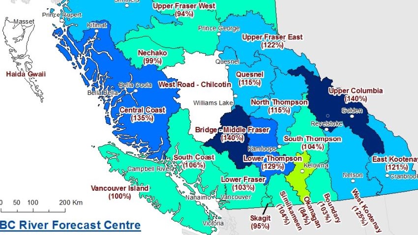
According to the River Forecast Centre, the data is from its 51 manual and 86 automated snow-weather stations. The average ranges from a low of 84 per cent in the Okanagan to 140 per cent in the Upper Columbia.
Normal snowpacks (90 to 110 per cent) were measured for the Upper Fraser West, Lower Fraser, South Thompson, Boundary, Similkameen, South Coast, Vancouver Island, Skagit, Peace and Stikine regions.
Slightly above-normal snowpacks (110-120 per cent) were recorded in the North Thompson and Skeena-Nass.
The River Forecast Centre said regions with above-normal snowpacks (120-130 per cent) were the Upper Fraser East, Middle Fraser, West Kootenay and East Kootenay, while the Central Coast and Upper Columbia had well above-normal snowpacks (130-plus per cent).
Notably, the entire Fraser River basin is at 110 per cent.

For the Okanagan, last year’s snowpack at this time was much higher, at 132 per cent.

Get breaking National news
“What is different this year (for the Okanagan) is that there’s a lot more low-elevation snow,” said Jonathan Boyd, a hydrologist with B.C.’s River Forecast Centre.
For the Lower Fraser, that basin is at 103 per cent, down from 115 last year, while the South Coast is at 106 per cent, down from 109.
Heading east, the West Kootenay range is at 125 per cent, up from 101 last year, the East Kootenay district is at 121 per cent, up from 94 and the Upper Columbia is at 140, up from 119.

“What is interesting,” said Boyd, “is that all of those three areas all had one weather station at all-time record-high measurements.
“And all three areas are at the highest levels they’ve been for Jan. 1 since 2008. So it’s abnormally high for the East and West Kootenay and the Upper Columbia.”
The River Forecast Centre says wet weather and seasonable conditions will continue, which translates into expected precipitation.


“One of the ways that we predict what will happen for the rest of the season is just whether it’s an El Nino, La Nina or neutral year,” said Boyd.
“And like last year, this year is also a La Nina year. And typically what happens for La Nina years is cooler-than-normal temperatures through the winter and early spring, and slightly wetter, particularly in the South Coast which can spill into the Southern Interior.”

Boyd said weather conditions last December and January were much warmer than normal, which undid La Nina conditions.
“This year is following more typical La Nina patterns,” said Boyd. “So I’d say, across the board, we’re pretty much at normal to above-normal snowpack (levels), except for the Okanagan.
“That’s the one anomaly where it’s a little lower than normal right now.”
The River Forecast Centre says if regular La Nina conditions occur, then expect more snow and rain for the rest of winter.
“By Jan. 1, about 50 per cent of the total snow has accumulated,” said Boyd. “So we still have about half of the season to go.”

Comments
Want to discuss? Please read our Commenting Policy first.