
Ever build a tower of Legos? Or stack a pile of hockey pucks?

They’re worlds apart, but those two simple examples somewhat describe this year’s complex snowpack in B.C., where some snow layers have bonded well, while others aren’t connected at all.
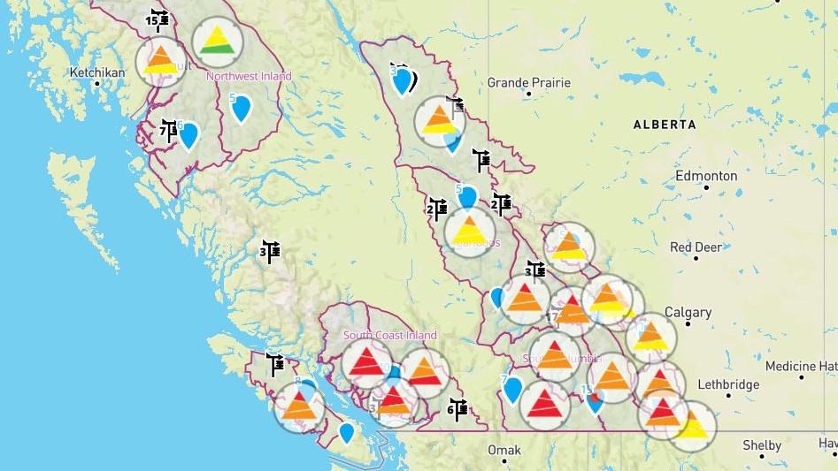
For Avalanche Canada, the winter of 2021-22 is proving to be a busy one, with the B.C.-based organization having issued many forecast warnings across the province this year.
For example, in B.C.’s Kootenay-Boundary region, danger ratings are high, from below the treeline to the alpine, with Avalanche Canada stating “avalanche conditions are very dangerous due to heavy accumulations of new snow, warming temperatures expected throughout the day, and a weak layer in the snowpack.”
Along the South Coast, Avalanche Canada had high danger ratings for the treeline and alpine regions as of Wednesday, plus a considerable danger rating for below the treeline.
The warnings for the South Coast are expected to drop somewhat by Friday, though Avalanche Canada is advising to “avoid all avalanche terrain during periods of heavy loading from new snow, wind or rain.”
It added that “the more the snow feels like a slurpy, the more likely loose wet avalanches will become,” and “if triggered, loose, wet avalanches may step down to deeper layers resulting in larger avalanches.”

In an interview with Global News, Avalanche Canada agreed that this winter has certainly been challenging.
“It’s been a bit of a roller-coaster. I think everybody knows that,” said Karl Klassen, warning service manager for Avalanche Canada in Revelstoke.
According to Klassen, it began snowing early this year, in October, which isn’t usual, but consistent snow in November and that month’s atmospheric river events “made a huge change to the snowpack structure in most of the province.”

Get breaking National news
More storms ensued, followed by a bitter cold snap, with more storms and now another atmospheric river this week.
Klassen said, “when you have those kinds of events, you get lots of layering in the snow.”
He continued, saying, “when you get these kinds of really wild swings, from really cold, dry spells to really wet spells, the layers are quite extreme, and often they don’t bond very well to each other.”

Klassen said there are several persistent weak layers this year, and they could be the kind that stick around for weeks instead of disappearing.
Asked about those two simple examples, Klassen said, “when you have Legos on top of hockey pucks, that’s when you have a slab avalanche.”
“The Legos will stick to themselves and make a cohesive layer while the hockey pucks are the weak layer that underlies that strong, firm cohesive layer.
“And when you have enough weight to that structure and you put it on an incline, the failure point will be where the hockey puck (layers) are because they’re not very well bonded to each other, and they’re not very well bonded to the layer above, either.”
Klassen said, “the analogy gives an idea of what the layering structure in a snowpack, like we have this year, looks like.”
- Edmonton’s stormwater system strained after repeated heavy rain
- First Nations chiefs call for inquiry into Ontario wildfire response
- How the Northern Tornadoes Project helps verify twisters as Alberta on track for record year
- Inquiry hears avalanche danger moderate on day of 2021 fatal Banff snow slide


Technically, Klassen said November’s atmospheric events created commonly seen layers called facet-crust combinations.
“The rain wets the snowpack. That then freezes into a solid crust and then we get facets, or sugary snow, that grows on top of that crust,” said Klassen.
“When you have that strong, underlying crust, with a facet of weak, sugary snow on top of it, and then you put your (bonded) slab on top, then you have the structure that sets us up for a slab avalanche.”
Sometimes those layers resolve and bond to become a uniform snowpack, but sometimes they don’t.
And this season, there are two or three layers in the snowpack that aren’t bonding as well as Avalanche Canada would like to see.

According to Avalanche Canada, this year’s snowpack isn’t uncommon, but the rest of winter and early spring “will be interesting and probably pretty tricky right through to the end of the season, with some of the layers we’re seeing developing.”
The warning service department of Avalanche Canada employs people across the province.
If you plan on visiting the backcountry, visit Avalanche Canada’s website before venturing out. Avalanche Canada posts daily forecasts.

Comments
Want to discuss? Please read our Commenting Policy first.