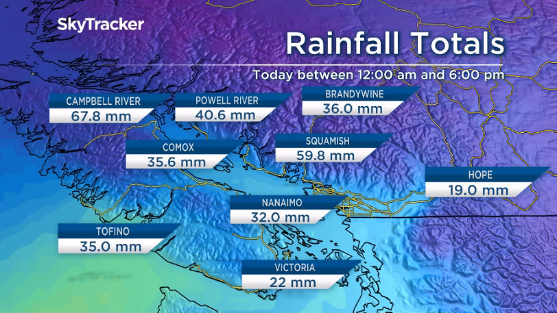
B.C.’s South Coast was drenched by the first big fall storm of the season Friday.

Rainfall warnings and concerns for strong winds were issued by Environment Canada as an intense cold front crossed the region.

The Vancouver International Airport reported 40.8 mm of rain by 4 p.m., the highest amount of rain in one day since January 2019, and 80 percent of the average rainfall for the entire month of September.
Other regions such as the North Shore mountains, northeast Metro Vancouver, Campbell River and Howe Sound recorded 45 to 60 mm of rain and more is on the way.

Get daily National news
The BC River Forecast Centre issued high streamflow advisories, as rivers are expected to rise rapidly late Friday through Saturday.

Some regions could see one-in-20-year flow rate and localized flooding could be an issue.
The Trans Canada Highway was closed between Lytton and Spences Bridge due to a risk of landslides.
Terrain impacted by wildfires over the summer is highly susceptible to dangerous debris flows during heavy rain events. The Ministry of Transportation is asking the public to not stop anywhere along roads affected by wildfires.
In addition, strong winds battered the region with gusts near the water up to 76 km/h.
BC Hydro said more than 7,000 customers were without power throughout the afternoon across northern Vancouver Island, the Sunshine Coast and the Lower Mainland.
The wind and rain will continue Friday evening but should begin to die down after midnight. Some areas could see over 80 mm of rain by Saturday morning.
Residents should keep their eye on the sky Saturday as the chance of rain continues. The rain will not be widespread but will come in waves and with a risk of thunderstorms.


Comments
Want to discuss? Please read our Commenting Policy first.