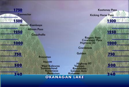

To locate yourself on this chart, imagine you are looking north in the Okanagan Valley.
All locations on the left side of the chart are to the west, toward the direction of Vancouver.
All locations on the right side of the chart are to the east.
Elevations are listed in metres; 1,000 metres is approximately 3,250 feet.
At sea level, 0³C is the freezing point of distilled water and 100°C is the boiling point of distilled water.
When you hear the phrase “snow level is dropping to 1,000 metres” that means precipitation occurring at that elevation will fall as snow.
Temperature generally falls as altitude increases; there is normally a drop of 6.5°C every 1,000 metres.
Lake level in the Okanagan Valley is 341 metres above sea level so, for example, if there is a stable atmosphere and the temperature at the valley bottom is 6.5°C, it will be freezing at 1341 metres.
Comments
Want to discuss? Please read our Commenting Policy first.