
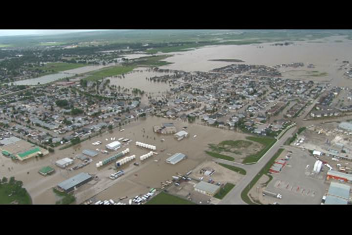
TORONTO – Signs of an impending flood in Calgary were evident months before the disaster struck.

A recent study by the University of California, Irvine, and NASA found that several areas across the United States are almost certain to suffer from water-related catastrophes. The one area likely to experience flooding stretches into Alberta and Saskatchewan.
The paper’s lead author, Jay Famiglietti, a professor of Earth Systems Science at the University of California, Irvine, is in Toronto attending the Munk School of International Affairs Program on Water Issues (POWI).
Read: Alberta government failed to act on flood prevention report
The research, using satellite data collected by the Gravity Recovery and Climate Experiment (GRACE) mission, a joint mission between the National Aeronautics and Space Administration and the German Aerospace Center, found that, although there were areas across the U.S. that were sure to face droughts, there were other areas — particularly in the north — that had an increase in groundwater saturation. It should have been evident that any extreme or extended weather event with precipitation would lead to a disaster and that included western Canada.

“When you look…you see it steadily increasing, so that the river basin is getting fuller and fuller…each year. So if you are a flood manager, or you’re in charge of flood prediction, you should be keeping your eye on that data. Because it can’t go on increasing in storage forever. At some point, you’re going to cross a capacity and that’s going to lead to flooding…and we just did it in Calgary.”
“GRACE can make a lot of contributions that are underutilized and could potentially save billions of dollars, and thousands of lives,” said Famiglietti.
Though there would have been no way to prevent the disaster, Famiglietti said — you still need the rainwater and snow to get those flooding conditions — it wouldn’t have taken people by surprise, and at least there could have been some measures to reduce the effects of the floodwater.
“It wasn’t preventable, but predictable,” said Famiglietti. “It’s almost inevitable, given the upward trend…that whole blue spot goes straight up north right up to Calgary. I was surprised…and not surprised.”
Famiglietti said that research he’s conducted, soon to be published, shows that utilizing the GRACE satellite will give areas a lead time for flood prediction by a few months. “And that’s a lot of time to allow you to divert water from a reservoir or divert water out of a river.”
“That map, the GRACE data…it really points to a lot of predictability that we’re not taking advantage of. And a lot of that predictability comes from the groundwater.”
“I would say, we should have seen this coming months ago,” Famiglietti said. “And thought about taking precautions.”
The GRACE mission was launched into orbit in 2002. The mission consists of two satellites about 220 km apart in a polar orbit 500 km above Earth. The satellites study changes in Earth’s gravity by measuring static influences like the sea floor and the continents, but also the water’s influence, which includes ocean currents, water runoff and groundwater storage.
Comments