

Travellers already frustrated by multiple ferry cancellations this weekend are reaching their boiling point Sunday, with sailings being held until the evening due to high winds and heavy snow.

BC Ferries has posted several cancellations for major routes between Metro Vancouver and Vancouver Island, with vessels not set to begin departing again until after 6 p.m.
Sailings between Tsawwassen and both Swartz Bay and Duke Point were cancelled throughout the day, along with sailings between Horseshoe Bay and Departure Bay.
Daytime sailings were still in place between Horseshoe Bay and Langdale, but sailings between 5:30 p.m. and 9 p.m. have been cancelled. However, the route’s modified schedule still shows some evening sailings in place.
All sailings for the remainder of the day have also been cancelled between Tsawwassen and the Southern Gulf Islands, while routes between Port McNeil, Alert Bay and Sointula have seen afternoon cancellations.
You can find a full list of cancellations here, along with information about refunds for reservations.

BC Ferries announced it has added extra sailings to Monday’s schedule, including a 8 a.m. sailing from Swartz Bay and a 10 a.m. sailing from Tsawwassen.
While those are the only confirmed sailing additions so far, a spokesperson said that could change.
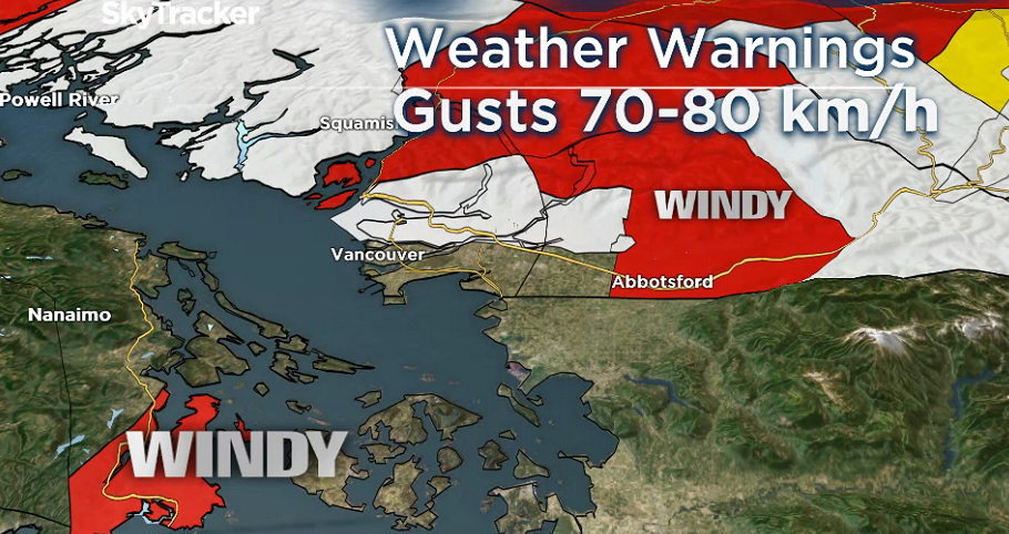
A wind warning remains in effect for Greater Victoria, with Environment Canada estimating gusts as high as 70 kilometres per hour.
A similar warning is also in place for Metro Vancouver, including Richmond and Delta in areas near the water.
Winds are anticipated to pick up later Sunday in the Fraser Valley, which could see 80 kilometre per hour gusts.
A snowfall warning remains in effect for Metro Vancouver, including the North Shore, after the region already woke up to another dumping of snow Sunday morning.

Get breaking National news
A further five centimetres is expected to fall later Sunday afternoon, while higher elevations of West Vancouver, North Vancouver and Coquitlam could see an additional five centimetres.
The snowfall in Vancouver, Burnaby and other low-lying areas will likely be wet and mixed with rain, forecasters said.
Tsawwassen, Delta and Richmond are seeing more rain than snow, however, as southerly winds keep temperatures moderate.
Areas like the Westwood Plateau and the North Shore mountains received up to 20 centimetres between late Saturday night and Sunday morning, while the rest of Vancouver saw between two and 10 centimetres.
Power out with several downed trees
The snow has been falling on the region since Saturday night, with rain mixed in at lower elevations to create sloppy conditions on the roads.
A break came in the late morning, but more snow is expected in the afternoon for eastern parts of Metro Vancouver like Coquitlam and Maple Ridge and into the Fraser Valley, which could see up to 5 more centimetres.


As of noon, BC Hydro said just over 1,500 customers were without power in Metro Vancouver. Close to 3,000 customers across the Lower Mainland and Sunshine Coast have been affected in total.
Over 400 customers in Vancouver’s South Granville neighborhood lost their power after a tree came down onto hydro wires. Other fallen trees have been reported in Surrey, Langley, Maple Ridge, Belcarra, Mission and Sechelt.
Other parts of B.C. were also seeing nasty winter weather Sunday.
The Sunshine Coast received up to 10 centimetres of snow in some areas, while snowfall warnings are in effect for nearby highways.
The Coquihalla is anticipating 10 to 15 centimetres to fall by Sunday afternoon, while drivers travelling along the Okanagan Connector are warned of blowing snow from Merritt to Kelowna.
Highway 3 will receive 10 to 15 centimetres of snow at Allison Pass, the Trans-Canada Highway at Eagle Pass will receive 5 to 10 centimetres of snow and Highway 3 at Paulson Summit will receive 15 to 25 centimetres of snowfall on Sunday.
Full information about road closures and conditions can be found on Drive BC.
An extreme cold warning is also blanketing much of the B.C. Interior, with temperatures set to plunge to at least -20 C. Other areas could get as cold as -40 C with the wind chill.
A full list of weather warnings for B.C. can be found on Environment Canada’s website.

Comments
Want to discuss? Please read our Commenting Policy first.