
What’s the first thing you think of when you hear the phrase “climate change?”

Forest fires, historic flooding and melting glaciers are just some of the examples of how Canadians have experienced the impacts of a changing climate and the extreme, unpredictable weather patterns that come along with it.
And while many of the impacts of climate change will be shared to varying degrees — like the increased frequency of more extreme and unpredictable weather — the way that manifests will likely look different in different parts of Canada, experts say.
READ MORE: Here’s where the federal parties stand on the carbon tax
“The major issue is the accumulation of threats, the multiplication of threats,” said Jackie Dawson, a professor at the University of Ottawa who holds the Canada Research Chair in Environment, Society and Policy.
“But they are different in different regions.”
With climate change already shaping up as one of the biggest issues on voters’ minds for this election campaign, here are some of the ways that climate change is predicted to manifest in Atlantic Canada, Central Canada, the West and the North.
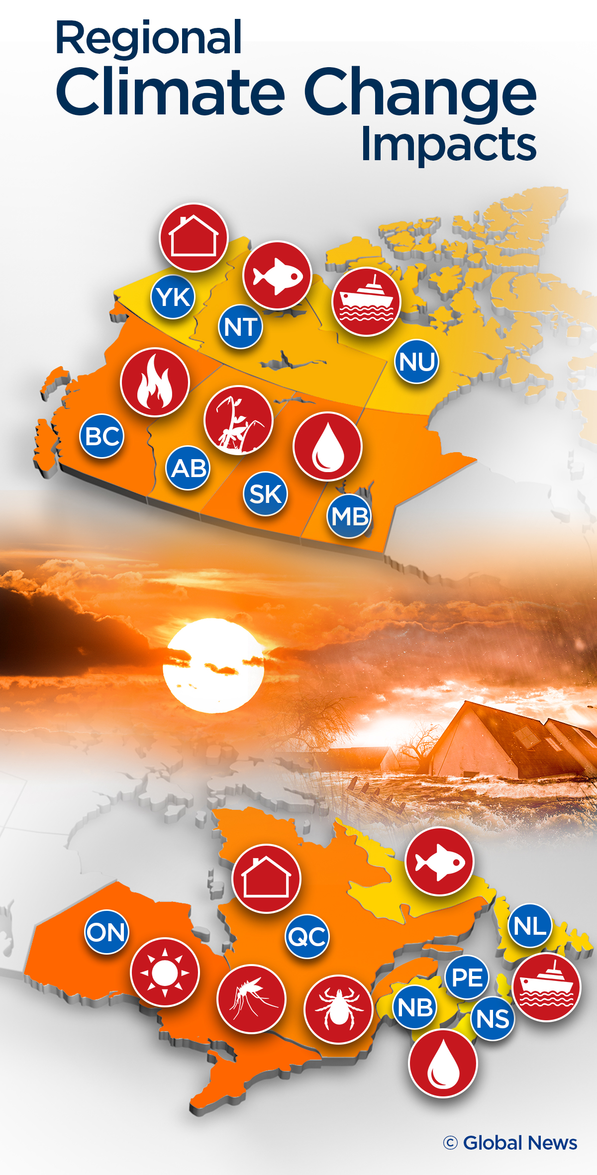


Atlantic Canada
According to the 2019 Canada’s Changing Climate Report, written by scientists from Environment and Climate Change Canada, Fisheries and Oceans Canada, and Natural Resources Canada, the impacts of climate change on Atlantic Canada will be diverse.
Sea ice will become thinner and form for much shorter periods of the year.
READ MORE: Two Canadian places that could be under water in 100 years — or sooner
Without the amount of sea ice the region usually gets, wave season will become more intense as a result.
“Wave heights and the duration of the wave season are expected to increase in the Newfoundland/Labrador coastal area during winter because of reduced sea ice extent,” the report states.
READ MORE: 100-foot rogue wave detected near Newfoundland, likely caused by hurricane Dorian
As the glaciers and Arctic ice melt, sea levels will also rise, increasing the risk of coastal flooding.
In fact, the report states that it is Atlantic Canada that will see the largest relative rise in sea levels out of the whole country — a rise of roughly 75 to 100 cm by 2100. As an example, the report suggests a rise of 20 cm in Halifax would lead to four times the flooding currently experienced.
And regardless of whether emissions drop or increase, that 20-cm rise is expected to happen within the next 20 to 30 years, the scientists predict.
That will have a direct impact in New Brunswick at places like the Tantramar Marsh or town of Sackville.
Both are predicted to be underwater by the end of this century as sea levels rise.
WATCH BELOW: Fish stocks not being properly monitored by federal government

They also note that as the ocean warms and subtropical waters shift north, the ocean will become saltier and warmer.
Warmer water also holds less oxygen than cooler water, and less oxygen would make some marine ecosystems less sustainable.
READ MORE: Canada’s fish stocks plummeting — Ottawa needs a ‘wake up call’ to save it: report
It’s worth noting researchers published an article in the journal Science in March 2019 that found warmer waters could actually help increase fish stocks in some regions, such as halibut off the coast of Newfoundland and Greenland.

Get daily National news
But others, such as Atlantic cod and albacore tuna from the North Atlantic, likely won’t fare as well.
“Although some species are predicted to respond positively to warming waters, the majority will experience a negative impact on growth,” the researchers wrote.
“As our world warms, responsible and active management of fisheries harvests will become even more important.”
So to sum up the key possible risks: rougher seas, more flooding and big changes to fish stocks.
Central Canada (Ontario and Quebec)
Much of the impact in Quebec will likely be a sort of hybrid of the effects also seen in Atlantic Canada as well as the North, the report suggests.
That’s because melting sea ice and warming waters in places like the Gulf of the St. Lawrence, James Bay and the eastern part of Hudson Bay will impact marine ecosystems in those regions, while the melting permafrost in place across much of the north of the province will also mean a heavy hit on communities as the shifting landscape and ground beneath them damages local infrastructure.
Waves are also predicted to get worse around the Gulf of the St. Lawrence for the same reason they will around Newfoundland: a lack of winter sea ice.
Oxygen levels in the Gulf have also already been found to be decreasing, the scientists wrote in their report.
According to the government of Quebec, temperatures in the southern part of the province have increased on average by one degree Celsius since 1950 and that’s expected to continue to increase over the coming decades.
READ MORE: Ticks are spreading across Canada. Here are their new homes
The result will be more heat waves and air pollution, as well as an increase in the length of hay fever season for allergy sufferers.
The hotter weather also raises the risk of more forest fires.
Ticks carrying Lyme disease are also spreading quickly through both Quebec and Ontario, with the introduction of West Nile virus in 2000 cited as an example by the Toronto and Region Conservation Authority of yet another disease spreading as its carrier is able to survive farther and farther north.
WATCH BELOW: The difficulty with diagnosing Canadians with Lyme disease

“Warmer water temperatures in Lake Ontario may allow new waterborne pathogens to move northward or existing ones to flourish,” the authority also warned.
Those warmer lake waters could also lead to fewer lake trout, yellow perch and largemouth bass, while lake sturgeon could disappear entirely.
As well, infrastructure damage is a concern in both Ontario and Quebec, particularly due to seasonal flooding and flash flooding in urban areas as storm sewers back up and spring flooding hits communities as the ice pack melts.
Escalating demands on energy infrastructure as heat waves hit the region will also contribute to the risk of blackouts.
So to sum up the key possible risks: hotter weather, the spread of disease, infrastructure damage and flooding.
The West (Manitoba, Saskatchewan, Alberta, B.C.)
The Canada’s Changing Climate Report suggests the rate of increase of the average mean temperature across the Prairies is greater than it is across the rest of the country, and that’s leading to a threat of more wildfires such as the devastating blaze in Fort McMurray in 2016.
READ MORE: This Alberta wildfire season has seen most hectares burned since 1981
It also notes that changing rain patterns will make droughts “more frequent and more intense” across the southern Prairie region in summers.
That could have a big impact on the agricultural industries based there, despite the fact that the growing season itself will likely get longer as a result of fewer days with frost.
READ MORE: Climate change might benefit Canada — but not enough to outweigh costs: expert
“It’s true that there is more arable land but as precipitation patterns change, we’re going to see less precipitation in some of those important growing areas, much longer droughts, more risk of forest fires, greater risk of floods,” said Kai Chan, a professor with the Institute for Resources, Environment and Sustainability at the University of British Columbia, in an interview with the West Block earlier this month.


Flooding, as Chan noted, is also among the risks facing this region for similar reasons as elsewhere, along with rising sea levels.
Communities like Richmond and Delta in the Lower Mainland are also forecast to be underwater by 2100.
As well, there could be a risk to some Prairie rivers given many flow from the mountains, which will see less snow and ice along with warmer temperatures.
WATCH BELOW: 5 years after the 2013 Calgary floods, how has disaster response changed?

Those glaciers in the western mountains are expected to lose roughly 90 per cent of their 2005 volume as a result of climate change.
That could lead to less water in the rivers during the summer months.
Not only will that impact the water quality of those rivers but also the potential for using them for hydroelectric power generation.
The same is true for rivers in the B.C. Interior, the Canada’s Changing Climate Report adds.
Lower oxygen levels as a result of warming waters have also already been detected in the waters of the Northeast Pacific, the scientists note.
Much like in the Atlantic, that will likely have “widespread and detrimental” effects on the marine life in that region, they added.
So to sum up the key possible risks: wildfires, droughts, changes to water supply and quality.
The North (Yukon, the Northwest Territories, Nunavut)
Northern Canada is set to face myriad challenges as a result of a warming climate.
While Canada is warming at twice the rate as the rest of the world, the North is warming at three times that rate, the Canada’s Changing Climate Report found.
That translates into a range of different risks, starting with the decrease in sea ice as a result of warmer temperatures.
Perennial ice — basically, ice that remains frozen over the course of years — is shrinking and being replaced by seasonal ice, which is effectively new ice that freezes and thaws over the course of a year.
READ MORE: Senate committee calls recommendations in Arctic report a ‘wake up call’
This matters because sea ice plays an important role in the way ocean waters move, potentially changing things like currents and other water patterns, and is also involved in reflecting back the energy from the sun so that it isn’t absorbed in the Arctic regions.
With less sea ice to do so, the increasing warmth can be more greatly absorbed and as the National Snow and Ice Data Center notes, set off “a cycle of warming and melting” that can contribute to temperatures becoming even warmer over time.
WATCH BELOW: Canada’s melting Arctic ‘major contributor’ to rising sea levels

Sea ice that drifts as larger formations break up can also pose a threat to ships and other vessels that will be using the Northwest Passage for commercial and research navigation purposes over the coming years.
On a similar note, shrinking glaciers will impact regional rivers and water sources, along with the potential for energy generation.
READ MORE: Permafrost in Canadian Arctic thawing 70 years earlier than predicted: study
One of the major threats to the North, however, comes from the thawing permafrost.
As this layer of permanently-frozen ground thaws, landscapes can collapse and shift — with big implications for surrounding infrastructure.
In fact, the Canada’s Changing Climate Report called the need to understand how climate change will impact permafrost “essential” to understanding how to adapt the North for the challenges of a warming climate into the future.
A house built on permafrost, for example, will become more susceptible to mold as the ground becomes wet and soggy, as well as cracks to the foundation and general structural damage as the ground shifts beneath it.
Infrastructure like roads will also be vulnerable — both from thawing ice roads and damage to the quality of dirt and paved roads from collapsing or shifting earth around them, combined with limited access to the building resources needed to repair them given the high cost of transporting goods to the North.
Local animals will also be impacted, including marine life and land life.
For communities that use subsistence hunting and trapping, changes to the flora and fauna around them will mean changes to the food and supplies they are able to gather from traditional methods as well.
So to sum up the key possible risks: damage to infrastructure that will be difficult to repair, changes to the availability of vital resources, and increased risks for those navigating and living in the region.
Comments