
As Bermuda braces for impact from powerful hurricane Humberto, forecasters say a number of other storms with the potential to cause damage and flooding are brewing.

Global News chief meteorologist Anthony Farnell says this is the most active part of hurricane season.
“This season is putting on a show with above-normal activity expected to continue into October,” he said.
Here’s a look at what’s happening.
Category 3 hurricane Humberto
According to the U.S. National Oceanic and Atmospheric Administration (NOAA), the outer rainbands of hurricane Humberto began to affect Bermuda on Wednesday morning.
WATCH: Weather maps show Hurricane Humberto headed for Bermuda

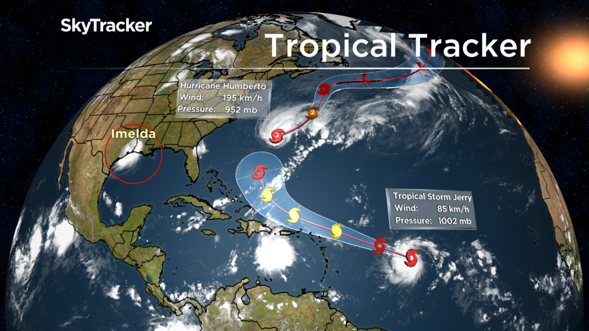
On Tuesday, the U.S. National Hurricane Center (NHC) announced the storm had been upgraded to a Category 3 hurricane.
In an update Wednesday morning, the NHC said hurricane conditions are expected in Bermuda overnight and into Thursday morning.
“Storm surge and dangerous breaking waves could cause coastal flooding tonight and Thursday along the southern coast of Bermuda,” the update reads.
As of 11 a.m., Humberto was centred about 310 kilometres west of Bermuda with top winds of 95 kilometres per hour and was moving toward the island at 26 kilometres per hour.
The NOAA says Humberto has been forecast to pass just to the northwest and north of Bermuda on Wednesday evening with tropical-storm-force winds expected to begin Wednesday afternoon.
The service says swells will also continue to affect the northwestern Bahamas and the southeastern coast of the United States from east-central Florida to North Carolina over the next couple of days, creating “life-threatening surf and rip current conditions.”

Get breaking National news
According to Farnell, Humberto is expected to slowly weaken, but with a “huge” wind field, a hurricane warning is in effect.
“The storm will then race off into the middle of the North Atlantic,” he said.
Tropical storm Imelda
Meanwhile, another tropical storm named Imelda made landfall near Galveston, Texas, on Tuesday.
The NHC said early Wednesday that Imelda had weakened to a tropical depression and was located about 40 kilometres north-northwest of Houston.
Farnell says the largest concern associated with Imelda is not wind but flooding.
“It was the rain due to the very slow movement of the storm,” he said. “Flooding is likely to continue through Thursday across southeast Texas, including around the Houston area.”
In an update just before 12 p.m. ET, the U.S. National Weather Service (NWS) said “significant flash flooding” would spread inland over eastern Texas and that locations between Houston and Shreveport, La., could see more than six inches of rain this week.
In a tweet Tuesday evening, Houston Mayor Sylvester Turner urged residents to “pay close attention to the weather reports” and be careful while driving.


Texas Gov. Greg Abbott on Monday placed numerous resources on standby across Texas. The Texas Division of Emergency Management will be rostering four boat squads in coastal areas. The Texas Parks and Wildlife Department will also be moving boats to support the Beaumont area and adjacent regions.
Tropical storm Jerry
On Wednesday morning, the NHC announced that tropical storm Jerry had become the 10th tropical storm to be named during the Atlantic hurricane season.
According to the NHC, Jerry is expected to strengthen and become a hurricane as it moves near the northern Leeward Islands on Friday.
The NHC says the storm is moving west-northwest at around 22 kilometres per hour.
According to the centre, it is “too soon to determine if there will be any direct impacts on the island.”
“Most computer models have Jerry narrowly missing the islands then re-curving back into the Atlantic without impacting North America,” Farnell said.
However, he said it is too soon to tell what the outcome will be.
“So stay tuned,” he said.
Tropical storms Lorena, Kiko and Mario
Meanwhile, Farnell says the eastern Pacific is also “very active” with tropical storms Kiko, Mario and Lorena.
“All three are tropical storms but all are expected to intensify to hurricane strength,” he said.
Farnell says the storm to watch is Lorena as it brushes the southwestern coastline of Mexico.

In a 10 a.m. update on Wednesday, the NHC said Lorena is forecast to move “dangerously close” to the coast of southwestern Mexico later Wednesday and overnight.
Mexico has now declared a hurricane warning for part of its southern Pacific coast, stretching from the resort town of Puerto Vallarta down near the port of Manzanillo.
Tropical storm warnings extend further, past Puerto Vallarta and down to Zihuatanejo.
In an update, the NHC says “preparations to protect life in property” should be “rushed to completion.”
The NHC says tropical storm Lorena is forecast to cause heavy rain over portions of the Mexican states of Guerrero, Michoacan, Colima and Jalisco over the next few days.
“This rainfall may produce life-threatening flash flooding and mudslides,” the centre says.
The NHC says Lorena had maximum sustained winds of 100 kilometres per hour on Wednesday morning. The tropical storm was reportedly located approximately 195 kilometres south of Manzanillo and was moving northwest at 13 kilometres per hour.
— With files from the Associated Press
Comments
Want to discuss? Please read our Commenting Policy first.