

At least 20 people are dead in the Bahamas, millions have evacuated their homes in the Carolinas and U.S. President Donald Trump is still tweeting and showing off doctored Hurricane Dorian projections to “prove” he didn’t make a mistake about Alabama being in its path.

The president has spent much of this week stubbornly defending a tweet he issued ahead of the storm on Sunday when he incorrectly stated that the hurricane was projected to hit Alabama. The National Weather Service immediately pointed out that Trump was incorrect, but he has repeatedly doubled down and defended the tweet.
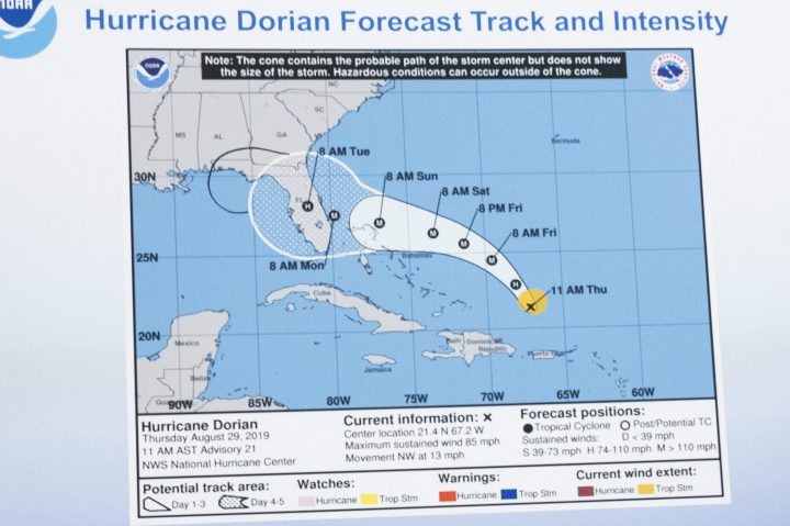
The controversy reached a new level of absurdity on Wednesday when the president showed off a seemingly doctored map projecting Hurricane Dorian’s path at a photo op in the Oval Office. The map showed a white cone of uncertainty over Florida and a seemingly hand-drawn black loop that extended its path over Alabama.
The map is dated Aug. 29, meaning it was six days old when Trump held it up to prove his point. And it still didn’t include Alabama.
The unusual map addition triggered a flurry of mockery on Twitter, where users shared images with crudely-drawn additions that favoured Trump’s world view. People used Sharpie-style edits to improve Trump’s inauguration crowd size, buff up his physique and build his border wall with Mexico.
One person even went so far as to scribble out Prime Minister Justin Trudeau from a viral photo he had with Melania Trump at the G7 Summit last month.


When asked on Wednesday about the apparently hand-drawn addition to the map, Trump offered no explanation.

Get breaking National news
“I don’t know, I don’t know, I don’t know,” he said. “I know that Alabama was in the original forecast,” he added, before claiming that there was a “95 per cent chance probability” that Alabama would have been hit.
The highest probability issued for any U.S. region in Dorian’s potential path is 60 per cent, the Associated Press reports.
READ MORE: Former PM Kim Campbell issues apology after ‘rooting’ for hurricane to hit Trump’s Mar-a-Lago
Trump doubled down on his Alabama claim Thursday morning in the middle of a two-pronged Twitter rant. (His other target was actress Debra Messing.)
“Alabama was going to be hit or grazed, and then Hurricane Dorian took a different path (up along the East Coast),” he tweeted.
Several users questioned why Trump would not simply admit a mistake and move on — something he has rarely done during his tenure as president.
“It’s okay to be wrong sometimes, y’all,” user @rebelkellll wrote. “Don’t be like this man.”
Comments
Want to discuss? Please read our Commenting Policy first.