

A major, upper ridge of high pressure pushing in heat and sunshine from the United States continues to push in the heat on Thursday, with a special weather statement for the hot air still in effect.

In addition, a special air quality statement continues in the South Okanagan for smoke from wildfires burning in the area, reducing air quality.
It has been a difficult firefight, with daytime highs soaring as high as 38 degrees on Wednesday in the Osoyoos and Oliver areas, but relief is on the way.
A few clouds will bubble up in the South Okanagan on Thursday afternoon, with temperatures climbing into the mid-30s throughout the valley with sunny skies continuing elsewhere.

Get daily National news
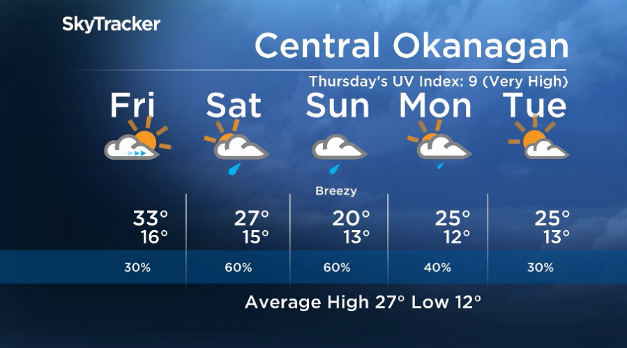
Friday will mark a shift in the weather pattern, with clouds building in during the day with a chance of a late-day shower and a risk of a storm in the afternoon, as afternoon highs dip to around 33 degrees.


An upper level trough will arrive this weekend, bringing in much-needed moisture, with showers likely at times both days.
Daytime highs will stay in the mid-to-upper 20s on Saturday, with the mercury struggling to get into the 20s on Sunday as breezy winds pick up.
Unsettled weather will stick around for the second week of August, with partly-to-mostly cloudy skies, a chance of showers and daytime highs returning to the mid-20s.
For weather on the go download the Global News SkyTracker Weather App for iPhone, iPad or Android.
Comments
Want to discuss? Please read our Commenting Policy first.