

Blizzard conditions slide out of Saskatchewan with a risk of precipitation in areas that missed out over the weekend.

Spring snowstorm
Southern Saskatchewan was hit hard by a late-April snowstorm with some areas receiving almost half a metre of snow.
Forty-five centimetres of snow fell in the Eastend area with wind gusts as high as 87 km/h, reducing visibility to near zero in some areas.
As the precipitation-packed low-pressure system swept through the province it forced the closure of the Trans-Canada Highway on Sunday before the storm began to move off to the southeast late in the day.

Weather forecast
Monday
-10 is where temperatures fell to behind the system in Saskatoon and Regina with wind chills making it feel like the minus teens to start the day.
Regina stayed below freezing all morning while Saskatoon managed to warm up to 7 degrees heading into the noon hour where the mercury will make it into double digits for an afternoon high.
There is a chance of late day showers in the Saskatoon area with a few more clouds building into Regina later in the day with conditions struggling to get into mid-single digits for a daytime high.

Get daily National news
Monday night
Both cities will fall back into the -6 to -8 range as skies clear back out overnight.
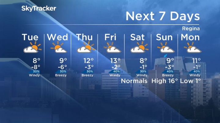
Tuesday
-13 is around what it’ll feel like with wind chill early Tuesday morning before temperatures make their way back into double digits for Saskatoon and into high single digits in Regina.
Clouds roll back in during the day with a chance of late day showers that could flip over to a risk of evening snow in Saskatoon.

Wednesday-Friday
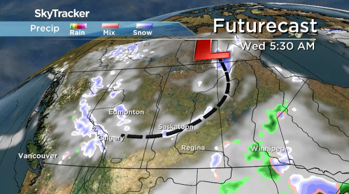
A lingering trough will keep conditions unsettled for the rest of the week with a chance of rain and snow on Wednesday, changing to a risk of showers for the rest of the week under mostly cloudy skies.
- Thorhild, Westlock counties declare state of agricultural disasters due to rain
- ‘Prolonged stretch of hot air,’ poor air quality advisories blanket the Prairies
- 2 tornadoes touched down in Rocky Mountain House, Environment Canada confirms
- Heavy Nova Scotia rain threatens flooding on anniversary of deadly 2023 flash flood


Daytime highs will settle into low double digits with morning lows starting the day just below freezing.
Weekend outlook
There is the potential for some showers over the weekend with daytime highs dipping back into high single digits or low double digits.

Manitou Beach was the setting for Kathleen Schlosser to take the Your Saskatchewan photo for April 29:

The Saskatchewan weather outlook is your source for the province’s most accurate forecast and is your one-stop shop for all things weather with comprehensive, in-depth analysis that you can only find here.
For weather on the go download the Global News SkyTracker Weather App for iPhone, iPad or Android.
Comments
Want to discuss? Please read our Commenting Policy first.