
It’s been a difficult, snowy, frigid winter for much of Canada, but spring is just around the corner — really.

But don’t get the shorts and T-shirts out just yet because it looks like the first half of the month will still include plenty of cold and wintry precipitation for a good part of the country.
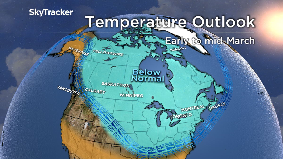
Frigid conditions are likely to hold on for a few more weeks:
But it won’t last forever.
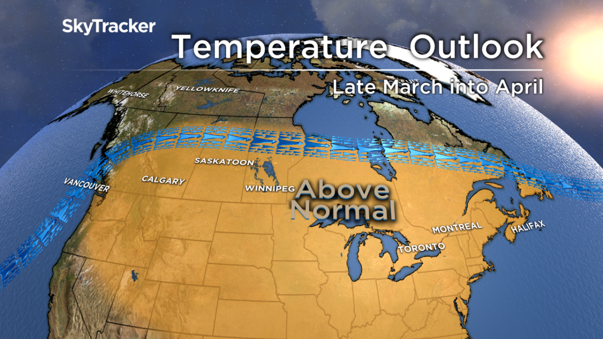
Last spring, winter won the fight early on, lasting well into April. This year looks like a different story with spring weather appearing when many Canadians hope it will arrive — around the vernal equinox (start of spring on the calendar) which is on Wednesday, March 20.
WATCH: When will winter end?

What will bring on this change? One of the factors is a continuing (possibly strengthening) El Nino, a weather pattern bringing warmer-than-normal sea surface temperatures to the equatorial Pacific. It looks like this El Nino will have enough of an impact on the jet stream to allow more of a Pacific flow of air to move across the country instead of arctic air. But before that happens, arctic blocking will still allow for cold and stormy conditions to prevail across much of the country until at least the middle of March.
The good news is, Canada is in for a warm spell in a few weeks.
Here is a detailed look at what Canadians from coast to coast-to-coast can expect.

Get daily National news
British Columbia
After higher than normal snowfall and colder than normal temperatures on the South Coast this February, most of B.C. will also see a break from wintry weather. Warmer than average temperatures will start to move in by mid-to-late March and that should last into April.
WATCH: B.C. residents tackle snow as region blanketed by winter weather

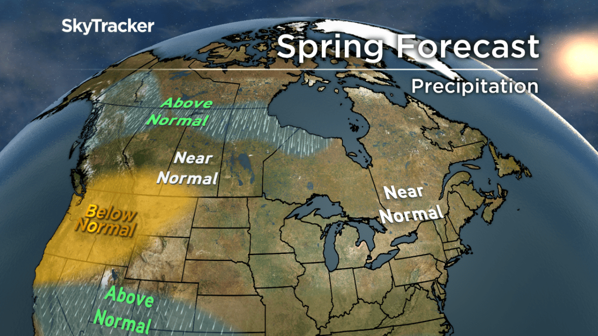
Near-normal amounts of precipitation are expected for the South Coast and Interior but above-average precipitation is expected for the Central and North Coasts as the storm track rises north.
A gradual, not sudden, warm-up would ease the risk of flooding due to a melting snowpack and near-normal to possibly below-normal amounts of precipitation expected for Southern B.C. would also help alleviate the risk of high water flows.
Prairies
After what has seemed like an endless winter, finally, some relief is in sight from the brutal cold that has gripped the Prairies. Early to mid-March will still have bouts of extreme cold from Calgary to Winnipeg, but as the month progresses, a gradual warm-up is expected.
Pacific air will finally push out the frigid arctic air mass which has taken up residence over this part of the country for months. That’s not to say arctic air won’t make an appearance again in April or even May, but those events should be short-lived.
WATCH: Alberta cold snap creates stunning images of light pillars


Precipitation amounts look to be near normal when averaged out over the entire period, but the better chance of seeing wet weather will be during the latter half of spring. A drastic rise in temperatures could lead to worse flooding along the Red River Valley in Manitoba.
Ontario and Quebec
The first half of March will include more snow, wintry precipitation, and intrusions of arctic air but spring weather can be seen at the end of what has seemed like an endless winter tunnel.
WATCH: February ends with another winter storm in Toronto

The pattern change will take form in mid-to-late March with above-average temperatures likely moving in just in time for the official start of the spring season. Precipitation amounts should average out at normal for the entire season. Some flooding could occur if a drastic warm-up quickly melts what has been a deep snowpack for many areas this season — especially in parts of Northern and Eastern Ontario.
Atlantic Canada
March will start off colder than average and stormy for this part of the country. However, by mid-to-late March, the Maritimes should start seeing a shift to above-average temperatures and a less active storm track.
That’s not to say there won’t be any intrusions of cold air at times in April and May, but the overall signal looks to be pointing at above-average temperatures and near-normal amounts of precipitation.
WATCH: New Brunswickers dealing with costs of budget-breaking winter

If the warm-up is too drastic by late March, there could be a risk of flooding in areas that see a mounting snowpack during the first half of the month — one area to watch will be New Brunswick.
Yukon, NWT, Nunavut
Northern sections of the country will also see a warm-up come mid-to-late March. Nunavut will see the warmer air move in later than territories to the west.
As expected, arctic air will still return at times into April and May but the signal at this point looks to be temperatures near-normal, with near-normal amounts of precipitation, although western sections of Yukon will likely see higher-than-average amounts.
Comments
Want to discuss? Please read our Commenting Policy first.