

Biggest blast of snow and cold of the year kicks off February.

Snowfall warning/winter storm warning
Environment Canada issued a snowfall warning for Saskatoon, Prince Albert, North Battleford and much of central Saskatchewan.
Ten to 20 centimetres of snow by Saturday as a slow-moving system tracks through.
Winter storm warnings have been issued for the Humboldt, Yorkton and Canora areas for 20 to 30 centimetres of snow combined with gusty easterly winds causing reduced visibility in blowing snow.
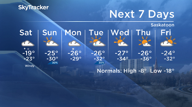
Saskatoon forecast
Friday
Snow started falling in Saskatoon late Thursday night and continued into the day on Friday with approximately four additional centimetres on the ground by morning.
Temperatures dipped back from around -14 degrees to -18 during the morning as a breezy northeasterly wind kicked in with gusts upwards of 44 km/h at times.
Snow intensifies during the day as pulses of precipitation associated with an atmospheric river bringing a moisture feed over the area slides in over a stationary front that could dump five more centimetres of snow.
Friday night
Conditions continue to cool through the evening before holding steady around -20 overnight as an additional 10 or so centimetres of snow falls.
Saturday
-30 is around what it’ll feel like with wind chill to kick off the first weekend of February as moderate snowfall continues to fall through the morning hours.
Snow will start to ease during the day as the main pulse of moisture pushes east and the frontal boundary slumps south allowing arctic air to sink in and keep temperatures around -19 or -20 all day.

Sunday
Mostly cloudy skies are anticipated Sunday morning, but there is a chance of some clear breaks and if those do occur temperatures will slide into the -30s quite quickly in the morning.
Clouds will roll in with a chance of flurries during the day with an afternoon high around -25 as wind chills sit in the -30s all day.


Workweek outlook
Snow slides back in on Monday, helping hold temperatures in the -20s before skies clear Tuesday into the middle of the week, which will allow the mercury to dive into the mid -30s overnight at times.
The first full week of February will be the coldest week so far this year for Saskatoon with daytime highs dropping into the mid -20s and morning wind chills as cold as -45 to -50 at times.
Lara McCarty took the February 1 Your Saskatchewan photo near Biggar:

Saskatoon weather outlook is your source for Saskatoon’s most accurate forecast and is your one-stop shop for all things weather for central and northern Saskatchewan with comprehensive, in-depth analysis that you can only find here.
For weather on the go, download the Global News SkyTracker Weather App for iPhone, iPad or Android.
- Canadian man dies during Texas Ironman event. His widow wants answers as to why
- ‘Shock and disbelief’ after Manitoba school trustee’s Indigenous comments
- Several baby products have been recalled by Health Canada. Here’s the list
- ‘Sciatica was gone’: hospital performs robot-assisted spinal surgery in Canadian first
Comments