
September 2018 was an almost bang-on average month when looking at the overall trend in Kelowna.

Daytime highs trended 2 degrees colder than normal, but that was made up for with overnight lows that were 2.4 degrees above average.

So, overall, the region trended half a degree warmer than normal in the temperature department during the month.
Coming off an extremely dry summer, with not even half of the normal precipitation recorded in Kelowna, September recorded 34.5 millimetres of rain, which is 105 per cent of the normal amount of 32.4 millimetres.
After a wet start to October with 13.6 millimetres of rain reported in Kelowna during the first two days of the month, drier days have rolled in for the rest of the first week of the month, but they don’t last long.
Temperatures dipped back to 1 degree in Kelowna on Thursday morning, with clouds lingering into the middle of the day before clearing in the afternoon with a daytime high back into low double digits.
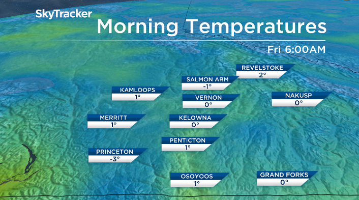
Clear skies on Thursday night will allow the mercury to plunge back below the freezing mark, with frost in the Shuswap, North and Central Okanagan for the first time in almost half a year.
Mostly sunny skies won’t last long Friday morning, with the next system swinging by to the south, kicking up clouds and a very slight chance of showers late in the day with an afternoon high in the low teens.
A risk of frost will also be in play on Saturday morning, as skies clear back out to bring in a beautiful mostly sunny start to the long weekend, with the mercury making it up into the mid-teens in the afternoon.
Sunshine and a risk of frost is slated to start off the day on Sunday as well, before clouds roll in with the next system later in the afternoon as temperatures aim to make it into the low teens.


The next round of rain is expected to roll into the Okanagan on Thanksgiving Day Monday as daytime highs drop back into low double digits with clouds and a chance of showers during the day.

Clouds and a chance of showers will linger into the beginning of the short work week ahead with afternoon highs settling into low double digits.

For weather on the go download the Global News SkyTracker Weather App for iPhone, iPad or Android.
Comments