
Air quality gradually improved during the week across the Okanagan, but thick smoke will slide back in across the region again soon.

The smoke-directing flow in the upper atmosphere transitioned to be more westerly throughout the week, pushing the main brunt of the smoke onto the prairies.
Apocalyptic scenes were experienced in major centres like Edmonton and Calgary, where air quality plunged to off-the-chart levels on Wednesday.

The highest concentration of smoke is being produced by fires in northwest B.C., particularly in the area around Treedsmuir Provincial Park, where hundreds of fires are burning.
A special air quality statement has been in effect for the Okanagan for more than four weeks now and it continues, reminding people having difficulty breathing to avoid spending time outdoors and remain inside in well-ventilated spaces.


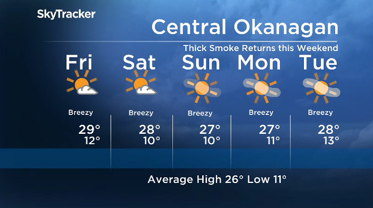
In the short term, air quality will continue to improve into Friday as a westerly flow continues aloft and the Okanagan experiences a second day with temperatures flirting with the 30 degree mark.
A few clouds and even some isolated pockets of showers and a couple of lightning strikes over high elevation areas are possible late Friday, after starting out the day in low double digits with a moderate-to-high air quality.

Get breaking National news
Saturday will be a transition day with a mix of sun and cloud at times, as the upper level flow switches around to be from the northwest and temperatures climb toward the upper 20s in the afternoon.
The transition to that northwesterly flow will start to truck back in the thick smoke and drop air quality and visibility down again during the day.
The flow directly from the heaviest smoke-producing zone in B.C. will be firmly established by Sunday, trucking in thick smoke that may obscure visibility down below a kilometre at times and will likely drop air quality to off-the-chart levels once again.
Above the smoke will be some sunshine on Sunday, as temperatures struggle to get into the mid-to-upper 20s with a breezy northerly wind expected at times right through the weekend.
A smoky start to the work week is expected under sunny skies with daytime highs into the mid-to-upper 20s, but a substantial shift is expected late in the week that should start to clear out the smoke.
For weather on the go download the Global News SkyTracker Weather App for iPhone, iPad or Android.
Comments
Want to discuss? Please read our Commenting Policy first.