
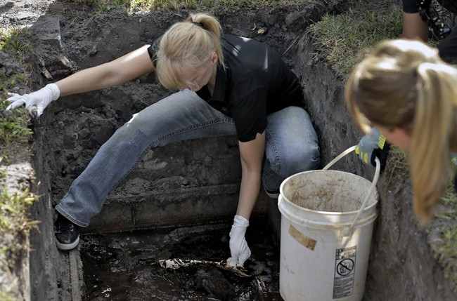
Five years ago, researchers at the University of Tennessee buried 10 bodies in a plot of land meant to simulate the spot — undeveloped, covert — that a murderer might select for his victim.

On level ground, the researchers dug four pits of varying sizes with pickaxes and shovels. Into one pit, they put one body, into another they put three, and into the third they put six. They left the last pit empty as a study control. They shovelled dirt back over the piles.
The donated bodies were made to replicate the macabre conditions under which someone might be buried this way. There were no coffins and some were only partially clothed while others were bound with ligatures. Researchers buried them with bullet casings, keys, and gloves.
Over the next 21 months, they scanned the area four times using LIDAR, a mapping technique that stands for Light Detection and Ranging and has been recently used to map floodplains and find ruins of ancient Mayan cities. In Tennessee, they mounted the LIDAR on a tripod and surveyed their mock crime scene with its pulsed laser light measuring the ground’s elevation levels.
What they found could prove useful for investigators trying their best to find where missing persons, their cases long gone cold, might be buried.
“Human graves change the ground surface. No matter their size, every grave contains a combination of disturbed soil and excess mass,” says the study.
It was published in the August edition of Forensic Science International.
“This study demonstrates that LIDAR can reveal subtle differences in elevation change that might otherwise be invisible, and therefore overlooked.”

Get daily National news
WATCH: Okanagan will use LiDAR to map flood plain

Once you know where the grave is, the study’s authors wrote, you can search for answers: how did they get from where they were last seen to here? How were their last moments spent? Who killed them?
There are millions of missing people around the world.
“Unmarked graves are difficult to locate once the ground surface no longer shows visible evidence of disturbance, posing significant challenges to missing persons investigations,” the authors wrote.
“Without knowledge of the location of an unmarked grave, communities can endure prolonged distress. … Without physical evidence of their crimes, perpetrators may benefit from impunity.”
But will Canadian investigators use LIDAR?
While it’s no “magic solution,” Myriam Nafte, a forensic anthropologist who excavates and processes gravesites across North America, said, “this is equipment that would be helpful.”
- How the Northern Tornadoes Project helps verify twisters as Alberta on track for record year
- Calgary area ‘very uniquely situated’ for study of hailstorms, says researcher
- New Asia Highlands exhibit, with some new species, opens at the Calgary Zoo
- Scientists find sugar in the Milky Way. It could help answer a cosmic mystery


However, it’s most helpful when investigators already have a rough idea of where a person might be buried. Usually, Nafte said, someone’s either found a bone or an item of clothing that indicates a rough area. Alternatively, they’ve talked with a witness who saw the victim walk off to a certain area with the perpetrator that investigators can then choose to search.
It’s not realistic to put a LIDAR in the sky and attempt to map all of Saskatchewan with no direction, she said. “Time and budget constraints are too big.”
Global News reached out to a number of police agencies on Thursday. The RCMP said it wasn’t able to respond in time, while the Ontario Provincial Police and Winnipeg Police Service both said they do not use LIDAR technology. They didn’t answer questions about whether there were any plans in the works to use LIDAR.
Where a LIDAR could be most effective for investigators, Nafte said, is in old cases.
“It’s best used when graves are old, when the regular vegetation has grown in and the soil has settled and it doesn’t look disturbed anymore.”
That’s why Luis Fondebrider and the Argentine Forensic Anthropology team sometimes uses LIDARs. His team is continually searching for the bodies of thousands of people killed as a result of government-orchestrated violence during Argentina’s Dirty War.
It’s not uncommon, Fondebrider said, for anthropologists searching for victims of political violence to “experiment” with commonly used anthropological equipment.
His team uses the LIDAR in the same way that Nafte said isn’t often feasible for resource and cash-strapped police agencies. They put it in a plane, Fondebrider said, and send it to cover wide swaths of land that may be difficult to look at on the ground because of buildings or forests.
“It’s a way to narrow down searches in big areas,” he said. “We are in an experimental phase but in the future we hope we can apply this to more cases.”
Comments
Want to discuss? Please read our Commenting Policy first.