

The air quality, fog and visibility situation improve as winds pick up.

Winter 2017-18
Meteorological winter contains the months of December, January and February, and overall in Saskatoon it was colder and drier than normal.
Despite December and January trending warmer than average, February’s whopping 5.6 degrees colder than normal pushed the season below average, which is what we had anticipated for winter back in the fall.
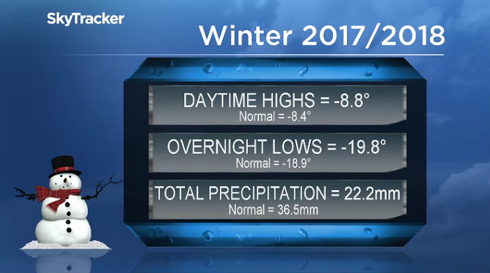
Saskatoon only received 61 per cent of our normal precipitation at the airport.
22.2 millimetres of melted snow and other forms of precipitation was reported throughout the season, when on average we see 36.5 millimetres.
Saskatoon Forecast
Wednesday
400 metres was where visibility fell down to Wednesday morning with thick fog to start the day before it started to burn off by mid-morning under beautiful blue skies and sunshine.
-23 is what it felt like Wednesday morning with wind chill as the mercury fell back to -16, but we warmed right up into mid-minus single digits as winds picked up to 30 km/h by noon.
Winds remain brisk for the remainder of the day with temperatures topping out just above the freezing mark in the sunshine.
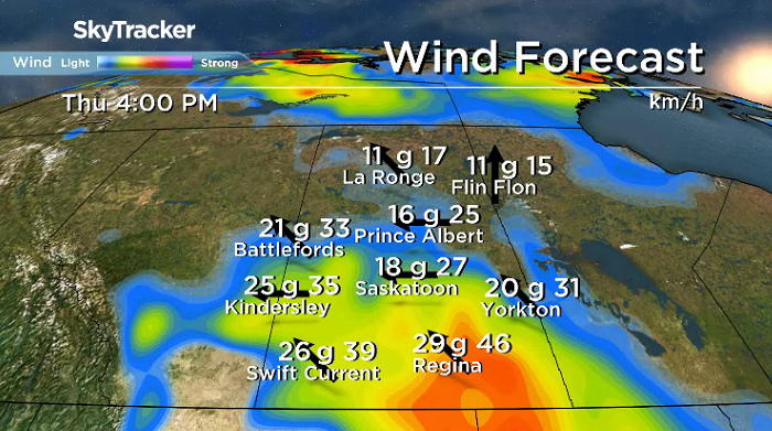
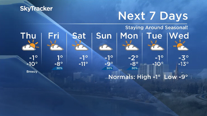
Thursday
-19 is what it will feel like with wind chill to start the day on Thursday under a mix of sun and cloud with breezy winds continuing from the east-southeast with gusts upwards of 40 km/h possible during the day.
A more organized deck of clouds associated with a system pushing in from Montana will move in late Thursday as we rise up to an afternoon high just shy of the freezing mark.
Friday
Mostly cloudy skies with a slight chance of flurries moves in on Friday as that system centres itself in southern Alberta and dumps lots of snow on that area.


We should manage to make it up to an afternoon high just above the freezing mark to round off the week.
Weekend Outlook
Mostly cloudy skies are likely to continue through the weekend along with a slight chance of snow as we rise up to afternoon highs just shy of the freezing mark.
Osler was the setting for Mishauna Taekema to take the Your Saskatchewan photo for March 14:

Saskatoon weather outlook is your source for Saskatoon’s most accurate forecast and is your one stop shop for all things weather for central and northern Saskatchewan with comprehensive, in depth analysis that you can only find here.
- Canadian man dies during Texas Ironman event. His widow wants answers as to why
- On the ‘frontline’: Toronto-area residents hiring security firms to fight auto theft
- Honda’s $15B Ontario EV plant marks ‘historic day,’ Trudeau says
- Canadians more likely to eat food past best-before date. What are the risks?
Comments