

Another accumulating snowfall is expected ahead with a roller-coaster of temperatures on the way!

Snowfall Warning
Environment Canada has issued a snowfall warning for La Ronge, Prince Albert National Park, Pelican Narrows, Creighton and Buffalo Narrows for 10 to 15 centimetres of snow expected.
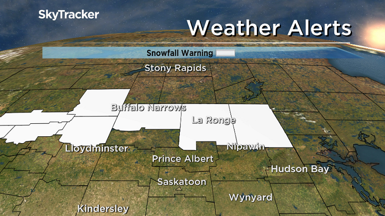
An approaching disturbance from Alberta will bring heavy snow from Buffalo Narrows to Pelican Narrows, beginning Monday evening and expanding eastward to La Ronge and Pelican Narrows before tapering off Tuesday afternoon.
Visibility may be suddenly reduced at times in heavy snow.
For the latest weather alerts download the Global News Skytracker weather app for iPhone, iPad or Android.
Saskatoon Forecast
Monday
It was a misty morning in Saskatoon with thicker fog found in other parts of the province where Environment Canada issued a fog advisory for visibility down to near zero at times.
After dipping back to -14 overnight, we warmed up a few degrees by morning, with wind chills down to -17 before warming up into mid-minus single digits before noon under mostly sunny skies.
Temperatures climbed up above freezing for the first time this month Monday afternoon under mostly sunny skies.

Get daily National news
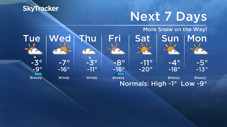
Tuesday
A fast-moving Alberta clipper will swing by early Tuesday and bring us back into the clouds with a good chance of snow later in the day and into the early evening.
-15 is around what it’ll feel like with wind chill in the morning and as the system slides through, we’ll see cooler air drop in with breezy northerly winds kicking in and keeping our daytime high in mid-minus single digits.

Wednesday-Friday
Chilly air will drop us into the mid-minus teens Wednesday morning with wind chills in the mid -20s to start the day with clouds rolling back in during the day and an afternoon high a few degrees into minus single digits.
- Thorhild, Westlock counties declare state of agricultural disasters due to rain
- ‘Prolonged stretch of hot air,’ poor air quality advisories blanket the Prairies
- 2 tornadoes touched down in Rocky Mountain House, Environment Canada confirms
- Heavy Nova Scotia rain threatens flooding on anniversary of deadly 2023 flash flood


The next system swings through with five to 10 centimetres of snow possible Wednesday night into Thursday with winds gusting up to 50 to 60 km/h and temperatures rising up further into minus single digits.

Behind that next system there is expected to be some clouds to end the week on Friday with a chance of flurries as temperatures fall back again, with an afternoon high around -8.
Weekend Outlook
Arctic air dives back in to start the weekend in the -20s with wind chills around -30 Saturday morning under mostly sunny skies with a daytime high in minus double digits before a slightly warmer Sunday with a high back into minus single digits with a few more clouds.
The Nov. 13 Your Saskatchewan photo was taken by Tammy Vallee at Île-à-la-Crosse:

Saskatoon weather outlook is your source for Saskatoon’s most accurate forecast and is your one stop shop for all things weather for central and northern Saskatchewan with comprehensive, in depth analysis that you can only find here.
Comments
Want to discuss? Please read our Commenting Policy first.