After a summer of extremes, Canadians can’t be blamed for wondering what weather the fall will bring.

Record heat and dry conditions sparked an active forest fire season out West, while cooler and unsettled weather dominated the summer farther East.
In September, the pattern reversed with early-season cold and snow hitting parts of B.C. and Alberta and the “summer weather that was missing all summer” arrived in Ontario, through Quebec and the Maritimes.
What you see is not necessarily what you get for the rest of fall.
Developing La Nina
Temperatures over the equatorial Pacific Ocean are below seasonal and all signs point to a La Nina settling in this winter. For the first half of fall the effects will be minimal, but colder air will begin to build later in November and December across northern Canada and Alaska and it’s likely some of this cold air will get into the weather pattern across much of the country before Christmas.
Depending on the strength of the La Nina, colder than normal temperatures and above-normal snowfall in late November and December could be a sign that the rest of the winter won’t be an easy one for most Canadians.
Fall Forecast

Get breaking National news
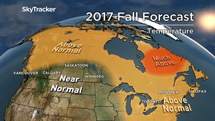
Western Canada
Cool weather will be replaced by above-normal temperatures for much of October and early November, followed by a back and forth pattern biased cool late in the fall. After a dry summer, it looks like below-normal rain and snow will continue until the La Nina-influenced parade of Pacific storms start lining up in late fall.
Prairie provinces
Near-normal temperatures are forecast across the south with warmer (relative to normal) weather confined to the northern Prairies. Back-and-forth weather will dominate with no prolonged cold or warm spells. Watch out in late November or early December, as this could be a warning sign for the winter ahead.
Ontario & Quebec
After a wet and overall cooler summer, it was a relief to get an amazing stretch of dry, sunny and warm weather in September. Unfortunately, a big ridge sitting overhead will break down the last week of the month and some cooler temperatures will settle in for a time into early October.
The pattern won’t hold, and we will see milder than normal temperatures return for much of the fall season. I am concerned for an early start to winter again this year with cold and snow in late November through December. Great for those hoping for a white Christmas — but it may catch some people off guard.
Atlantic Canada
So far, the Maritime provinces have been extremely lucky and have avoided the wrath of all those monster hurricanes to the south. Unfortunately, the season is far from over and hurricane activity in the tropics is forecast to remain active through October.
There is a concern that one of these will take the turn north and impact Atlantic Canada directly. The good news is that Jose and now Maria are mixing up some very cold water just off the East Coast so this could limit the intensity of any potential hurricanes that impact Atlantic Canada.
Either way, above normal rainfall is expected this fall with temperatures also remaining warmer than normal thanks to a large Bermuda High sitting off the East Coast.


Comments
Want to discuss? Please read our Commenting Policy first.