

Warm, dry July turns into a cool and dry start to August.

July 2017
July 2017 was warmer and much drier than normal in Saskatoon.
Overall temperatures were one degree warmer than normal, which was entirely because daytime highs were an average of 2.1 degrees warmer as overnight lows were actually bang on the normal value for the month.

The month was way drier than normal, with only 25.5 millimetres of rain reported at the airport, which is 42 per cent of our normal 60.3 mm.
Parts of northern Saskatchewan saw over double the normal July rain, with Buffalo Narrows receiving 174 mm when on average they see 80.1 mm.
That made 2017 the wettest July ever recorded for the community.
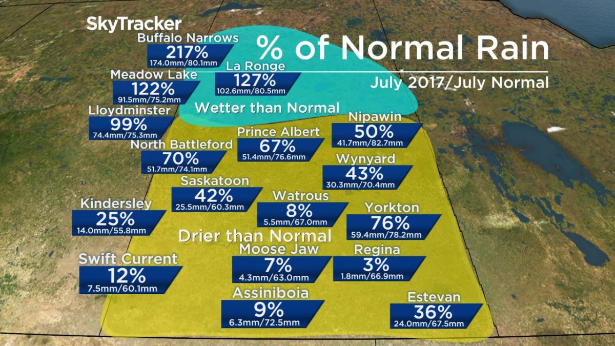
READ MORE: 1-in-100 year rain event in northern Saskatchewan
Meantime, it was one of the driest July’s on record in parts of the south, where many areas saw less than two millimetres of rain all month.
It was the driest July ever recorded in Moose Jaw.
Saskatoon Forecast
Tuesday
Partly to mostly cloudy skies kicked off August in Saskatoon with temperatures dipping back to 10 degrees Tuesday morning.
We quickly rose up a dozen degrees by late morning, which felt like the mid 20s with humidity.
Mostly cloudy skies stuck around for the rest of the day as we warmed up to a daytime high in the mid 20s with heavy pockets of rain moving in as an upper disturbance rippled by into the evening hours as temperatures fell back to 12 degrees overnight.
Wednesday
After a slight risk of rain to start the day, the upper disturbance that brought the showers will move out and bring the clouds along with it, which will return us into some sunshine during the afternoon.
An cool arctic high will dip in for the day and suppress temperatures, with a daytime high only topping out in the low 20s.


Thursday-Friday
After a single digit, but sunny start to the day Thursday, the mercury will rise back up into the mid 20s for a daytime high as clouds roll back in during the afternoon.
Those clouds will stick around on Friday and bring in a chance of rain as a weak upper low swings through and destabilized the atmosphere and we warm up to an afternoon high in the low-to-mid 20s.

Long Weekend Outlook
The long weekend won’t be out hottest weekend, but it will contain some cloud cover at times, some sunshine as well and daytime highs likely into the mid 20s across the board.

Marlee Clarke took this Aug. 1 Your Saskatchewan photo of a tornado touching down near Quill Lake on July 21:

Saskatoon weather outlook is your source for Saskatoon’s most accurate forecast and is your one stop shop for all things weather for central and northern Saskatchewan with comprehensive, in depth analysis that you can only find here.
- Toronto’s construction season traffic is ‘unacceptable.’ Is there a better way?
- More foreign interference action coming after inquiry report, India arrests: LeBlanc
- Nijjar arrests: Indian foreign minister says Canada welcomes ‘criminals’
- B.C. man losing vision needs to find home for treasured book collection
Comments