

Severe Thunderstorm Watch

Environment Canada has issued a severe thunderstorm watch for the Saskatoon, Prince Albert, Outlook, North Battleford, Kindersley, Rosetown and Meadow Lake areas.
Conditions are favourable for the development of severe thunderstorms that may be capable of producing strong wind gusts, large hail and heavy rain.
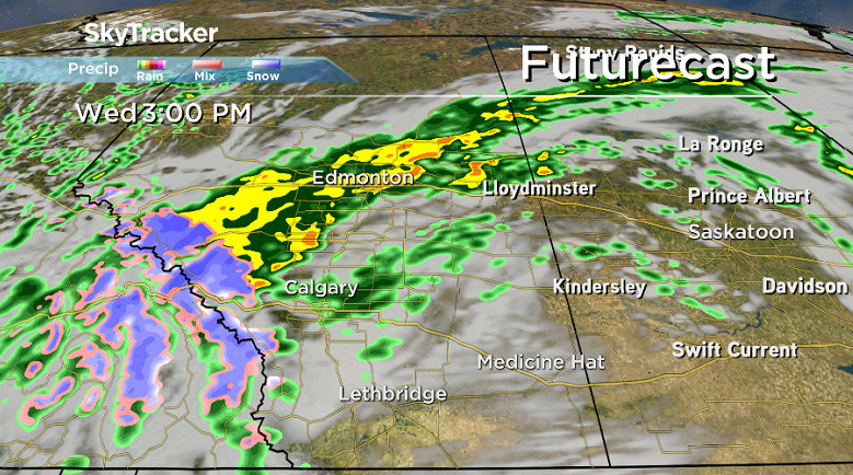
Thunderstorms are expected to develop early this afternoon over portions of central Saskatchewan along and ahead of a cold front approaching from the west. Some of these thunderstorms may become severe.
Funnel clouds are also possible as these thunderstorms develop.

Get daily National news
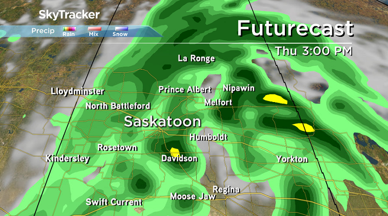
Significant accumulations of rain may occur over the Meadow Lake region later today into Thursday.
Wind Warning/Special Weather Statement
Environment Canada has ended a special weather statement for Saskatoon and parts of central, northern, southern Saskatchewan, but a wind warning and special weather statement remains in place for western and eastern regions of the province.
Heavy rain and strong winds will affect portions of Saskatchewan starting on Wednesday and continuing into Friday.
Environment Canada has issued a wind warning for the southwest corner of the province, including Regina, Humboldt, Weyburn, Leader, Maple Creek and Cypress Hills.
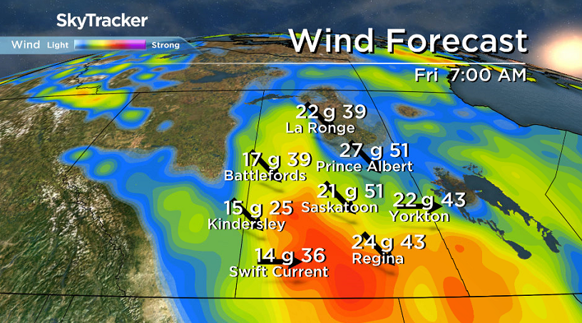
Winds are expected to increase to 60 km/h with gusts up to 90 km/h on Wednesday morning as an intense low pressure system moves into Saskatchewan from Alberta.
The winds will subside slightly in the afternoon, but gusty conditions are expected to last into Thursday.
Lloydminster is also under a wind warning, with strong northerly winds with gusts up to 100 km/h possible on Wednesday afternoon.
The strong winds in the border city are expected to last until the evening.
Environment Canada issues wind warnings when there is a significant risk of damaging winds.
Other parts of western Saskatchewan are under a special weather statement.
- Thorhild, Westlock counties declare state of agricultural disasters due to rain
- ‘Prolonged stretch of hot air,’ poor air quality advisories blanket the Prairies
- 2 tornadoes touched down in Rocky Mountain House, Environment Canada confirms
- Heavy Nova Scotia rain threatens flooding on anniversary of deadly 2023 flash flood


The low pressure system moving into the province, bringing rain and thunderstorms to those regions over the next couple of days.
The heaviest rainfall is expected in the Meadow Lake and Île à la Crosse regions, and towards the southern portion of Cree Lake, with 30 to 50 millimetres of rain likely by the end of Thursday.
Localized thunderstorms could give an excess of 75 mm of rain over the two-day period.
Strong northerly winds are also expected to develop on Thursday as the system passes through, with gusts up to 80 km/h possible towards the Alberta border.
For weather on the go download the Global News Skytracker weather app for iPhone, iPad or Android.
Saskatoon Forecast
Wednesday
Saskatoon started off the day at around 15 degrees under mostly cloudy skies. A few showers rolled through early in the morning before we got into some mid-morning sunny breaks.
Winds were pretty breezy from the south-southeast at sustained speeds of 40 km/h with gusts into the 50 to 60 km/h range at times, as we warmed up to 22 degrees by noon.
Thunderstorms rolled through in the afternoon with a wind gust over 100 km/h reported after we warmed up to around 24 degrees just after noon.
WATCH BELOW: Mitchell Webb captured this footage of the wind tossing some garbage bins around in Saskatoon’s Silverspring neighbourhood on Wednesday.

Funnel clouds and landspout tornadoes were possible across western Saskatchewan during afternoon as this low pressure system moved in with an unstable airmass in place and high vorticity values, which measure the amount of rotation present in the atmosphere.
READ MORE: How you can stay safe and save lives this severe weather season
Landspout tornadoes are generally weaker and shorter-lived that form when a rotating horizontal tube of air in a cloud gets tilted vertically by the updraft in a thunderstorm or cumulus cloud.
Landspouts can cause damage and carry winds in excess of 200 kilometres per hour.
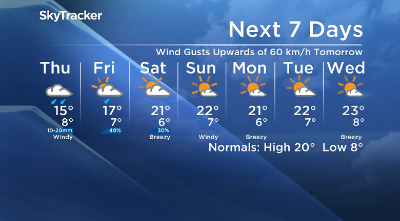
Thursday
The system responsible for the wild weather will slide into southeast Saskatchewan on Thursday and bring the Saskatoon area into some wrap around rain during the day with a risk of thunderstorms and funnel clouds once again.
Cooler air will slide in, keeping our daytime high in the mid-teens with northerly winds picking up to 30 to 40 km/h with gusts in the 50 to 60 km/h range.
Friday
The work week is expected to end on a slightly calmer note with winds starting to ease on Friday and a chance of showers under partly to mostly cloudy skies as the system starts to pull off.
It will be a cooler day, despite the chance of a few sunny breaks, with a northerly wind gusting in excess of 50 km/h, keeping our daytime high around 17 degrees.
Weekend Outlook
After a chance of showers early in the day on Saturday, clouds are expected to clear out by afternoon and remain mostly sunny for Sunday with daytime highs returning to the low 20s both days.
This Your Saskatchewan photo was taken in Warman by Wendy Miller:

Saskatoon weather outlook is your source for Saskatoon’s most accurate forecast and is your one stop shop for all things weather for central and northern Saskatchewan with comprehensive, in depth analysis that you can only find here.
Comments
Want to discuss? Please read our Commenting Policy first.