


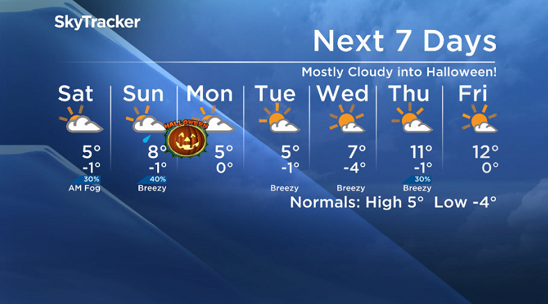
Fog, cloud and some showers for Halloween weekend! Here’s how it all breaks down.

Saskatoon Forecast
Today
Mist started the day before drizzle moved into Saskatoon early this morning as temperatures sat around two degrees.
The drizzle moved out of the area mid-morning, but the added moisture combined with a north-northeasterly wind around 20 to 30 km/h and a few other factors kept us cool through the morning.
We did manage to reach 3 C by noon with more precipitation set to move in this afternoon.
This next batch will likely fall predominantly as rain, but there is a chance of some wet snow mixed in.
The result of all of this will likely only allow us to hit a high of 4 C today.
Tonight
That chance of precipitation does linger into the evening before it eases off under cloudy skies overnight.
After such a moist day as we cool down to -1, temperatures will reach the dewpoint temperature in the city allowing for fog patches to develop overnight.
Saturday
There is a high pressure system that’ll slide by on Saturday that typically would bring in some sunshine, but this one will be what’s known as a “dirty high”, which means it’ll have cloud cover associated with it.
As such, we’re looking at a mostly cloudy Saturday with a very slight chance of precipitation in the morning and a daytime high around 5 degrees.
Sunday
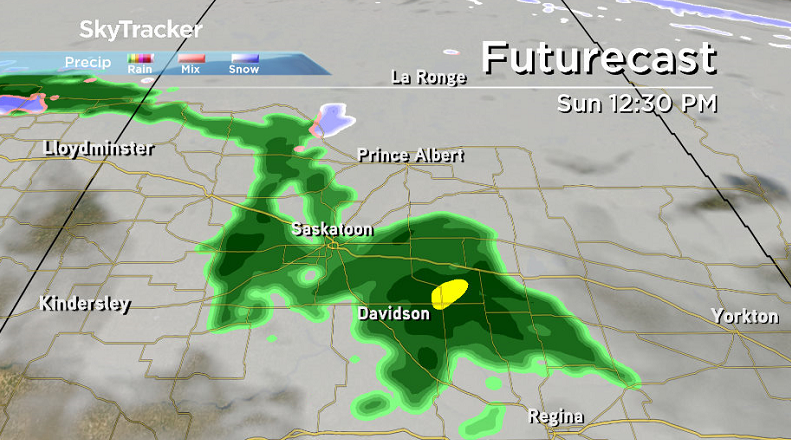
The next system will slide by on Sunday bringing in a slight chance of rain midday and it’ll also pull up our daytime high as we swing into the warm sector of the airmass.
So despite the mostly cloudy skies that are expected to linger throughout much of the day, the mercury will still likely top out around 8 degrees or so in the afternoon.

Get daily National news
Halloween
For all those ghouls and goblins hoping to hit the streets and trick-or-treat on Monday, I have some good news for you – that risk of rain we’ve been talking about in the evening is looking slimmer and slimmer!
Mostly cloudy skies will stick around through the day with temperatures creeping up to around five degrees in the afternoon before falling back toward the freezing mark in the evening.
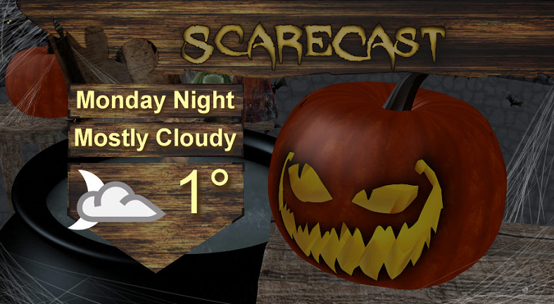
So that means prepare yourselves for temperatures between zero and three degrees if you’re heading out in your costumes for the evening!
Work Week Outlook
A few clouds will stick around on Tuesday as a system slides by north of the city with a daytime high again in mid-single digits.
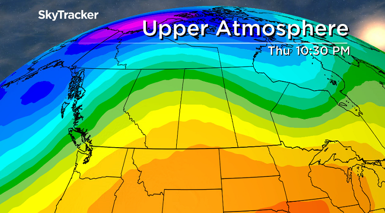
Sunshine then presses into the forecast even more through the rest of the first week of November with daytime highs pushing up into high single digits on Wednesday and then soaring into low double digits later in the week as an upper ridge of high pressure builds in to kickoff the new month.
- Ready for the harvest moon this weekend? Here’s what you’ll see in the sky
- End of the road coming for ‘End of the World’? Erosion impacts Edmonton viewpoint
- Tropical Storm Polo expected to become a major hurricane this week
- Record slow hurricane season, but Maritimers warned to stay vigilant about extreme weather


Wet October 2016
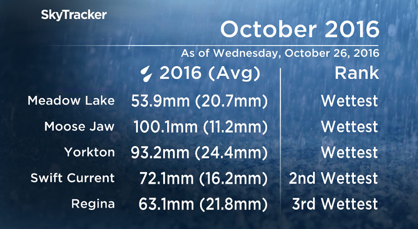
It has been the wettest October ever recorded for in a number of Saskatchewan communities including Meadow Lake, Moose Jaw and Yorkton where up to eight times the normal precipitation has fallen in some areas, and the month isn’t even over yet.
Moose Jaw has seen an impressive 100 millimetres fall when on average they only see 11.2 millimetres.
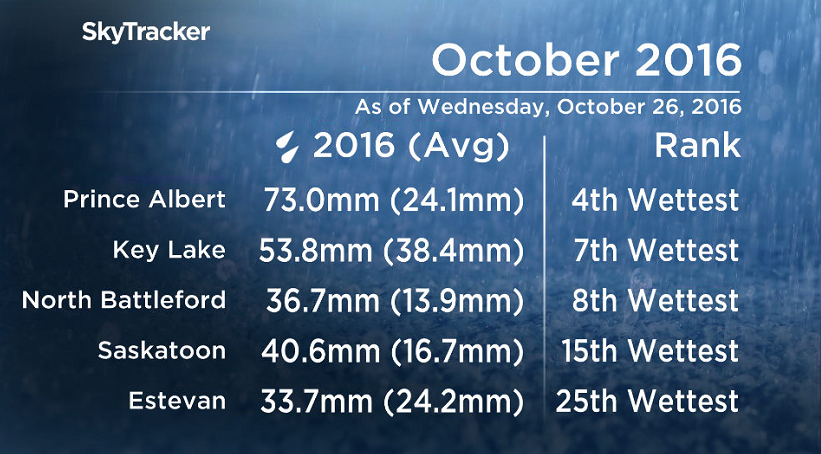
As of Wednesday, October 27, 2016, it has been Saskatoon’s 15th wettest October on record with 40.6 millimetres of precipitation having fallen so far, which is nearly two-and-a-half times the normal monthly total of 16.7 millimetres.
READ MORE: 100-year-old snowfall record surpassed in Saskatoon
Significant snow at the beginning of the month followed by moderate to heavy rainfalls later on have accounted for a large portion of these impressive totals.
WATCH BELOW: Schools closed, harvest halted devastating farmers from heavy snow

This Your Saskatchewan photo was taken by Darci McLashen in Saskatoon:

Saskatoon weather outlook is your one stop shop for all things weather for Saskatoon, central and northern Saskatchewan with a comprehensive look at your local forecast that you can only find here.


Comments
Want to discuss? Please read our Commenting Policy first.