TORONTO – Hurricane Sandy is expected to enter Canadian territory tonight, and Global News meteorologist Anthony Farnell says it will be a “monster storm.”

Who will it hit?
Farnell says millions of people along the U.S. East Coast will be affected we well as people in Canadian inland areas, including the provinces of Ontario, Quebec, Nova Scotia and New Brunswick.
“Tropical storm force wind gusts are likely hundreds of kilometres from the centre, knocking down trees and power lines,” he said. “There is also the potential for flooding and even snow mixing in across southern Ontario.”
Farnell expects the heaviest rain will be around the Niagara region and across southwestern Ontario, where it could reach 100 millimetres. He added the pressure gradient will likely funnel east winds along the length of Lake Ontario, bringing intense waves and a mini storm surge to areas like Hamilton and Burlington on Monday night and Tuesday.
When can we expect it?
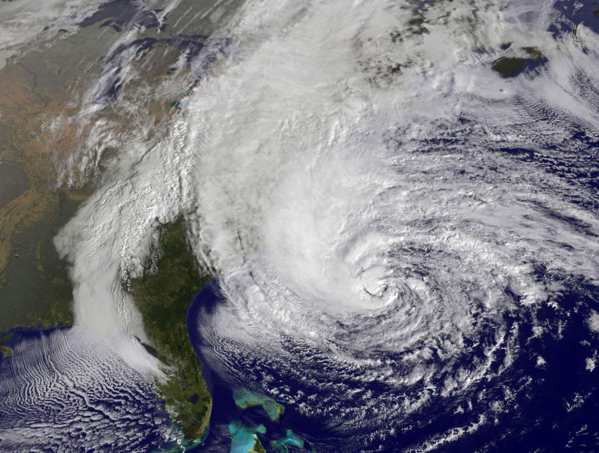
Hurricane Sandy bore down on the Eastern Seaboard’s largest cities Monday, and tropical storm force wind gusts are likely to be seen across southern Ontario and Quebec from Tuesday through Wednesday, when rain will also be heavier.

Get daily National news
“The storm in the west will dig in behind the hurricane and combine to invigorate Sandy on Monday,” explained Farnell. “The cold air clashes with the tropical air (Sandy formed in the Caribbean) to create more lift and further intensify the system, and winds also increase because of a stronger pressure gradient between a hurricane and a Canadian Arctic high to the northwest.”
“Here in Ontario…the rain will pick up in intensity late Monday, with winds also increasing and peaking very early Tuesday morning,” said Farnell. “Additional rainfall amounts of 50-75 millimetres shouldn’t cause a severe flood situation, but basement flooding and some river flooding is expected.”
‘Not your classic storm’
Farnell says this is a particularly dangerous situation for the coastal areas of the northeast, especially where bays and coves will funnel the storm surge. He says the extreme waves of 30-40 feet will crash above that, worsened by the fact that the moon is full on Monday night which creates an “astronomical high tide.”
“Winds will be very strong Monday night and Tuesday, with northerly 100 km/h gusts a possibility in Toronto,” said Farnell.
He added most heavy wind events happen with a west wind, so trees are more susceptible to damage.


“Luckily, most trees have lost their foliage so damage will be less…still expecting plenty of tree branch debris and power outages across all of southern Ontario, including the Greater Toronto Area (GTA).”
Farnell predicts the storm will weaken quickly after moving inland, but the rainy and windy conditions will likely last into Thursday morning.
How Sandy compares to other weather events
Farnell isn’t expecting the same outcome as 1954’s Hurricane Hazel, which left 81 dead and almost 2,000 families homeless as winds hit 124 kilometres per hour and rains flooded low-lying areas of southern Ontario after crossing the Caribbean and eastern U.S. However, he noted both Sandy’s track and the interaction with a strong cold front is similar to that of Hazel.
He says Sandy is also comparable to the ‘Perfect Storm’ of October 1991, but calls it even more “perfect.”
“In that situation-21 years ago to the day-it was a strong storm that captured a weakening hurricane Grace,” he recalled. “In this case, the hurricane is the main feature and another system will be collapsing in along with a strengthening jet stream, and some very cold air to the west.”
Farnell predicts many factors are combining to create a unique weather event: the enormous size of Sandy, the way the storm hooks back into the coast, the interaction with a strong jet stream and abnormally cold air.
“If the computer models are correct, this track is basically once in a lifetime.”
Comments
Want to discuss? Please read our Commenting Policy first.