

A warm-up kicks in just in time for the weekend before the weather pattern switches up again next week.

Saskatoon Forecast
Today
Mist and mostly cloudy skies started the day today with temperatures dropping back to around nine degrees overnight before recovering up into low double digits by morning.
By noon, Saskatoon sat at 15 degrees – that’s five degrees cooler than Thursday at the same time.
This follows two consecutive days with temperatures up to six degrees colder than the previous day!
Mostly cloudy skies associated with an upper trough swinging through lingered a little longer than expected and is expected to persist into the afternoon hours with a few sunny breaks possible later in the day.
Under a northerly flow today, conditions are once again expected to remain cooler with the mercury lingering in the low teens this morning, possibly only topping out in the high teens this afternoon depending on whether we can catch any sunny breaks later on.
Tonight
It looks like we’ll see some clouds sticking around tonight as temperatures dip back just into single digits once again.
Saturday
Mostly cloudy skies are expected tomorrow, but this time they’ll be high clouds with some mid and lower level clouds to start the day associated with the tail end of a warm front pressing in.
There’s a slight chance of a few sprinkles midday along the front and we may get some late day sunny breaks as well.
Temperatures look like they’ll likely recover back into the low-to-mid 20s tomorrow as a southerly flow kicks back in.
Sunday
Models are keeping us in the clouds to start the day on Sunday before some upper ridging starts to dominate later in the day that’ll help clear skies.
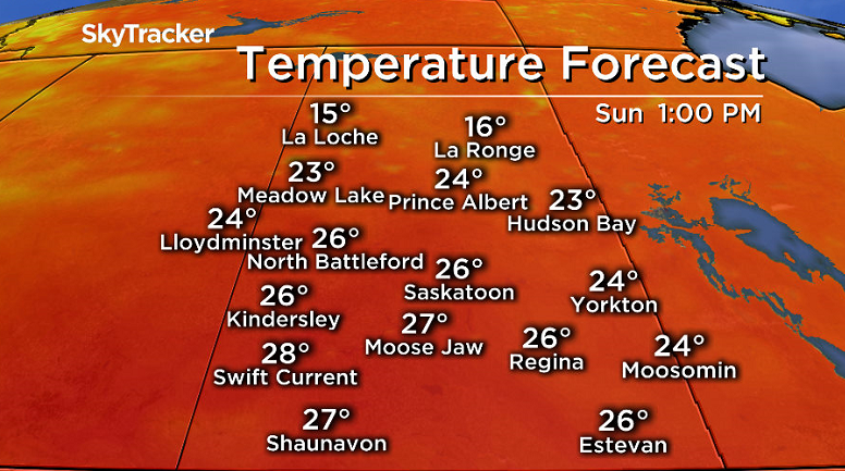


The mercury is expected to push even warmer into the mid to high 20s as we move into the warm sector of a developing low pressure system in Alberta.
Work Week Outlook
Monday looks like it’ll be partly to mostly sunny with daytime highs potentially pushing into the high 20s before that low pressure system and associated cold front sweep through into mid-week with a coupled upper trough keeping conditions cool, unsettled, windy and wet from Tuesday possibly until Thursday.
Daytime highs through the middle of the week look like they’ll struggle to hit the low 20s with the best chance of rain being Tuesday and Wednesday with a continued chance into Thursday.
This Your Saskatchewan photo was taken at the Rabbit Lake mine site at Wollaston Lake by Margaret Naldzil:

Saskatoon weather outlook is your one stop shop for all things weather for Saskatoon, central and northern Saskatchewan with a comprehensive, detailed look at your local forecast that you can only find here.
Comments