

NOTE: All advisories mentioned in this story have ended

Weather Advisory for Funnel Clouds
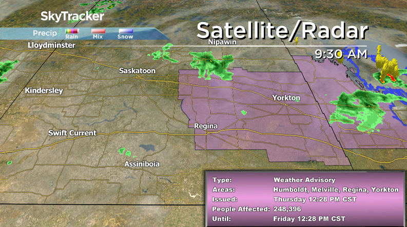
Environment Canada has issued a weather advisory for possible funnel clouds for the Regina, Humboldt, Wynyard, Fort Qu’Appelle, Moosomin, Wadena, Yorkton, Melville, Kamsack and Canora areas.
At 12:20 p.m. a funnel cloud was observed just south of Regina.
A low pressure system located over southeast Saskatchewan and southwest Manitoba will lead to scattered thunderstorm development Thursday afternoon and as these thunderstorms develop, conditions will be favourable for funnel clouds.
These types of funnel clouds are generated by weak rotation under rapidly growing clouds or weak thunderstorms that is normally not a danger near the ground.
However, there is a chance that this rotation could intensify and become a weak landspout tornado.
If conditions become more favourable for the development of landspout tornadoes, watches and warnings will be issued by Environment Canada.
Landspout tornadoes do not usually cause significant damage but can still be dangerous. They can be strong enough to topple trees, damage roofs or toss debris short distances.
READ MORE: What to do when you spot a funnel cloud

Get breaking National news
For the latest weather alerts download the Global News Skytracker weather app for iPhone, iPad or Android.
Rain in the West
Portions of west-central Saskatchewan were hit hard once again by heavy rain that fell overnight prompting Environment Canada to issue a rainfall warning for the region Wednesday evening.
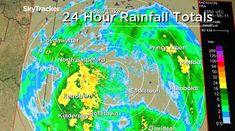
The North Battleford and Kindersley areas were hit with 40 to 60 millimetres of rain, while one isolated pocket near Wilkie saw 125 millimetres or so.
Localized flooding was reported on Highways 7 and 342.
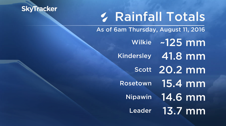
Here’s a look at some of the rainfall totals as of 6 a.m. Thursday morning.
Saskatoon Forecast
Today
Mostly cloudy skies started off the day with temperatures around 14 degrees.


We did get into a band of rain moving through around 10 a.m. that really was just enough to wet the pavement.
In Saskatoon temperatures are expected to climb a few more degrees this afternoon with just a slight chance of showers or a scattered thunderstorm later today.
Tonight
- Canadian woman charged with illegally crossing into U.S., kicking border agent’s face
- A new ‘cold’ war? Canada looks to bolster Arctic security, sovereignty
- Canadian furniture industry still ‘reeling’ after Trump pauses tariff spike
- Ottawa propose fines of up to $1M for violating foreign influence registry rules


The upper level low that’s been situated over our province is moving eastward into Manitoba, but there is still a chance of a scattered shower tonight as we drop down to around 12 degrees.
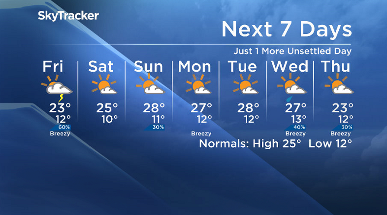
Friday
As the upper low continues to exit the region, clouds from that system will clear out in the morning, but then an upper trough/shortwave swinging through will keep the atmosphere unstable for the remainder of the day.
As such it doesn’t look like we’ll get too much of a break from the clouds through the day – although there is a chance at a few sunny breaks, mostly likely mid-morning.
As the upper trough moves in there is a risk of showers and thunderstorms in the afternoon as well.
The lack of rain early on in the day will help us warm up into the low 20s by late morning with an expected daytime high around 22 or 23 degrees in the afternoon.
Weekend
After all of the work week’s disturbances have moved out, it looks like all that rain will give us some gain in a mostly sunny Saturday and warm weekend to look forward to!
Temperatures should top out in the mid-20s on Saturday before they push up even further into the upper 20s for Sunday as a few more clouds move through with a slight chance of showers and thunderstorms.
Work Week Outlook
At this point models are keeping the upper ridge in place for the early portion of next week, which means mostly sunny skies and daytime highs in the mid-to-high 20s should stick around.
All good things must come to an end though…and this one may be rather abrupt.
Mid-week it looks like a fairly significant cold front and associated upper trough could come crashing through, giving us a cool end to what’s already the 3rd week of August.
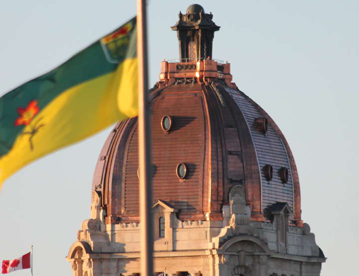
Cary Fischer snapped this Your Saskatchewan photo of the legislative building in Regina:
Saskatoon weather outlook is your one stop shop for all things weather for Saskatoon, central and northern Saskatchewan with a comprehensive, detailed look at your local forecast that you can only find here.
Comments