

Environment Canada has confirmed Saskatchewan’s fifth tornado of the season touched down near Estevan on Thursday.

The tornado touched down approximately eight kilometres east-southeast of the city of Estevan at 11:30 a.m. CT for about 5 minutes.
READ MORE: What to do when a tornado touches down in Saskatchewan
There are no reports of damage from the twister, but numerous videos surfaced on social media of the dust cloud it kicked up.
There was also pea-to-dime sized hail reported to be several centimetres deep in the Bienfait area.
A heavy downpour of rain dumped 79 millimetres of rain in under an hour on the Oxbow area as the storm briefly stalled over the area.
A weather advisory for possible funnel clouds was issued Thursday for the Humboldt, Wynyard, Melfort, Tisdale, Nipawin, Hudson Bay and Carrot River areas as well as in southeastern Saskatchewan during the day.
Funnel clouds were spotted near Greenwater Lake Provincial Park, Watrous and Estevan as well as a number of other areas.
A funnel cloud was also spotted just south of the border in North Dakota in some rare footage taken from a plane.
This is the third day in a row a weather advisory for funnel clouds has been issued in Saskatchewan.

Get breaking National news
Numerous funnel clouds were spotted around Saskatoon Wednesday.
READ MORE: Funnel clouds spotted around Saskatchewan Wednesday
Environment Canada says a lingering trough of low pressure created favourable conditions for funnel clouds in east-central sections of the Saskatchewan Thursday afternoon.
In the southeast an upper level disturbance caused the favourable conditions as it tracked along the international border through the day and moved out of the area during the evening.
These types of funnel clouds are generated by weak rotation under rapidly growing clouds or weak thunderstorms that is normally not a danger near the ground.
Environment Canada says there was a chance that the rotation could intensify and become a weak landspout tornado, but if conditions became more favourable for the development of landspout tornadoes, watches and warnings would be issued.
For weather on the go download the Global News Skytracker weather app for iPhone, iPad or Android.
Saskatoon Forecast
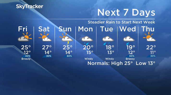
Here is your Saskatoon SkyTracker 7-Day Forecast.
Today
10 degrees was where we sat earlier today under partly to mostly cloudy skies that stuck around through the day as we pushed up into the low 20s just before noon.
There is a slight chance of showers or thunderstorms through the afternoon as temperatures climb up into the low-to-mid 20s.


Tonight
A few clouds will stick around through the night as temperatures fall back to around 12 degrees.
Friday
We’ll be feeling the heat again tomorrow as we get some ridging in the upper atmosphere helping push our high well into the mid-20s.
We may catch a few sunny breaks to start the day, but then the cloud cover will move in along with a chance of late day showers and the risk of a thunderstorm.
Weekend
As the upper ridge starts to break down this weekend, we get an ideal setup for once again, you guessed it – severe weather.
It looks like we’ll see mostly cloudy skies both Saturday and Sunday with a chance of showers and potentially severe thunderstorms across the board.
Daytime highs also look like they’ll stay quite warm, in the 25 to 27 degree range with sufficient moisture and atmospheric dynamics to fire off some strong storms.
Work Week Outlook
A bit of a washout is on the way early next week with rain, potentially heavy at times, expected until the middle of the work week as an upper low swings through.
Afternoon highs will also get pushed back into the high teens or low 20s during the first half of the week.
Dayne Winter took this Your Saskatchewan photo in Saskatoon:

Saskatoon weather outlook is your one stop shop for all things weather for Saskatoon, central and northern Saskatchewan with a comprehensive, detailed look at your local forecast that you can only find here.
Comments
Want to discuss? Please read our Commenting Policy first.