

UPDATE: All advisories mentioned in this story have ended

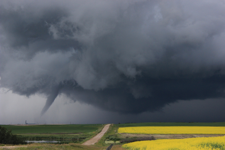
Funnel clouds are possible today in Regina, Moose Jaw, Saskatoon, Prince Albert and across much of central Saskatchewan where a weather advisory has been issued.

Environment Canada says there is a chance this rotation could intensify and become a weak landspout tornado.
READ MORE: What to do when a tornado touches down in Saskatchewan
Developing thunderstorms may produce funnel clouds Tuesday afternoon and some have already been spotted.


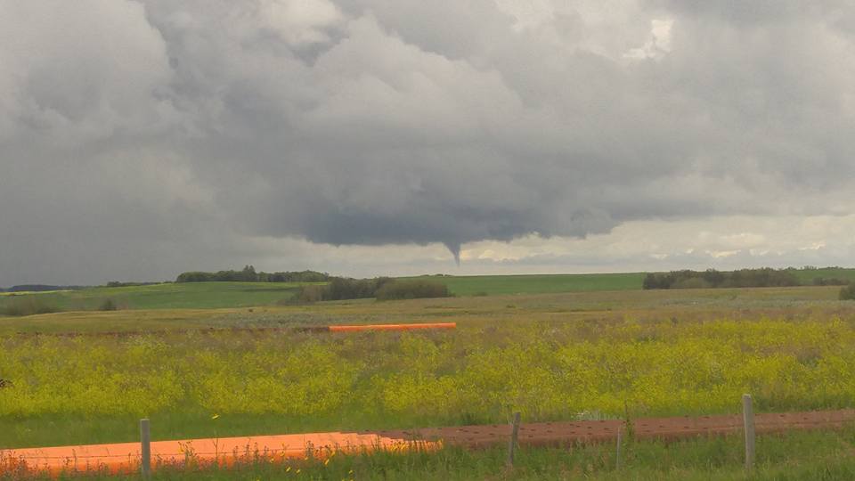


These funnel clouds are considered cold core and are formed from weak rotation under non-severe thunderstorms.

READ MORE: Officials say new SaskAlert app worked during weekend storms
- Real Canadian Superstore fined for ‘misleading’ Product of Canada displays
- Danielle Smith promises Alberta referendum over immigration, Constitution changes
- ‘No reason to continue discussing’: Ontario mayor wants Andrew’s name dropped
- Canadian Tire says Triangle Rewards are its ‘linchpin’ for growth


This rotation rarely reaches the ground, however a landspout tornado may develop if the rotation intensifies.

READ MORE: How you can stay safe and save lives this severe weather season

Get daily National news
For weather on the go, download the Global News Skytracker weather app for iPhone, iPad or Android.
Saskatoon Forecast
Today
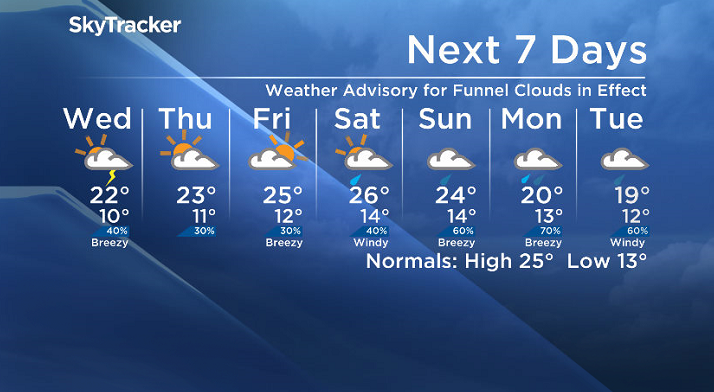
Dynamics through the atmosphere will remain favourable for the development of funnel clouds Saskatoon, central and eastern Saskatchewan into the afternoon before conditions begin to stabilize later in the day.
Saskatoon started the day with a few scattered showers with temperatures in the mid-teens after dropping back to 10 degrees overnight.


Partly to mostly cloudy skies are expected to continue through the rest of the day with a slight chance of showers or thundershowers this afternoon.
It’s been a slow warm up so far today, it took us until 1 p.m. to reach the 20s with a daytime high only expected to be a few degrees warmer.
Tonight
We may see a stray shower early this evening before partly cloudy skies linger through most of the night with a bit of clearing into the early morning hours as temperatures drop back to around 10 degrees once again.
Wednesday
Tomorrow looks to be a much similar day with a partly to mostly cloudy morning before an upper low that’s sitting in northwestern Saskatchewan starts to move closer to the area, keeping us unsettled with mostly cloudy skies and a risk of thundershowers through the afternoon.
It’ll also be another cooler day with an expected high around 22 degrees.
Thursday-Friday
We head into a gradual warming trend through the rest of the work week with some weak ridging in the upper atmosphere helping clear skies on Thursday and give us a sunny start to Friday before clouds return later in the day along with a risk of thundershowers.
Daytime highs will also jump up toward the mid-20s by the end of the work week.
Weekend Outlook
Most models have us on track for an unsettled start to the weekend on Saturday with a few upper disturbances rolling through bringing a good chance of showers and thunderstorms.
A trough starts to move in on Sunday bringing with it a good chance of rain before more organized, steady rain looks likely into the beginning of next week as an upper low, a big rain-making system, tracks in.
At this point, daytime highs through the weekend look like they’ll likely top out in the mid-20s both days.
This Your Saskatchewan photo was taken by Cheryl Hare of the Golden View Hutterite Colony on Canada Day, now confirmed by Environment Canada as the province’s fourth tornado of 2016:
Saskatoon weather outlook is your one stop shop for all things weather for Saskatoon, central and northern Saskatchewan with a comprehensive, detailed look at your local forecast that you can only find here.
Comments
Want to discuss? Please read our Commenting Policy first.