

We love the crackle, the subtle colours flickering and playing off our fold-out chairs in a backyard. There’s nothing like roasting the first marshmallow of the season as the heat of the day retreats into the air of a clear night.

But Environment Canada, Natural Resources Canada, and your friendly neighbourhood weatherman are all saying the same thing: don’t do it due to the extreme risk of fire. For the record, here’s their map:

That “extreme” zone in Saskatchewan encompasses Rosthern in the southeastern corner, and stretches up toward Cold Lake, Alta. Unity, Meadow Lake, and Battleford are included, too.
READ MORE: Traffic on Sask. Highway 16 resumes after grass fire crossed lanes
In the “high danger” zone, we add Prince Albert, Big River, Watrous, Regina, and Moose Jaw.

Get breaking National news
Now, the science.
Our jet stream continues modeling well to our north; this acts as a heat shield, allowing southerly products room to move on through. The high jet also means that the delightful little trough we have isn’t pulling the one low-pressure centre we’ve seen this past week any closer than it is.
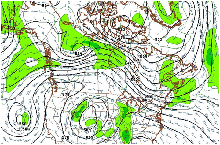
As a result of this bulwark, Saskatchewan will stay as dry as the United States was in 1926 (I googled “prohibition”). Further, high-pressure air to our east (and, in two days, from the north) will continue our dry trend a little while longer.
Once that starts to set in, we should see our heat rise on out (sorry, short-wearers), creating a stratiform layer that aims to put a couple millimeters of rain over us.
That said, it’s probably still not enough to contend with the other major fire-issue factor. Here’s a current map of our surface wind:
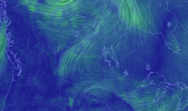
I made it wide-ranging, so you can identify the Great Lakes, and establish that directly over the Prairie provinces we have some strong, contentious winds linking around our high-pressure center (just north of Lake Superior) feeding into the low well north of us, and easily the most identifiable feature on this map.
Between contention of pressures and a drastic and continuous change in temperature, this paints us a tapestry of 30 km/h sustained wind the further north you try to move through the province.
From that, you can understand why I’m writing this. Stack it with a grand total of 0.7mm of precipitation for the month of April so far, and there’s a danger of fires being fed in a big hurry.
So, slap a bread tag on the marshmallows for a couple of weeks, and keep an eye on globalnews.ca/Saskatoon for all the latest on fire potential in Saskatchewan.
For weather on the go download the Global News Skytracker weather app for iPhone, iPad or Android.


Comments
Want to discuss? Please read our Commenting Policy first.